
Eastern Mojave Vegetation
By Tom Schweich
|
Eastern Mojave Vegetation | Images -- Geography - Idaho |
|
By Tom Schweich |
|

Unclassified Geography - Idaho Geography - Park County, CO Geography - Summit County, CO Geography - Arizona Geography - British Columbia Geography - California Geography - California's Colorado Desert Alaska Geography - Mono Lake Basin, California Geography - Mono County, California Geography - San Luis Obispo County, California Geography - Marin County, California Geography - Santa Clara County Alameda Garden Geography - Central Mojave Geography - New Mexico Geography - Eastern Mojave Geography - Northern Mojave Geography - Colorado Geography - Alamosa County, CO Geography - Boulder County, CO Geography - Clear Creek County, CO Geography - Chaffee County, CO Geography - Douglas County, CO Geography - Gilpin County, CO Geography - Golden, Colorado Geography - Weld County, CO Geography - Hinsdale County, CO Geography - Jefferson County, CO Geography - North Table Mountain, Jefferson Cty, CO Geography - Lake County, CO Geography - Larimer County, CO Geography - Nevada Geography - Oregon Geography - Utah Geography - Virginia Geography - Washington Geography - Wyoming Spain - Andalucia Spain - Castilla y Leon Spain - Castilla-La Mancha Spain - Extremadura Spain - Galicia Spain - Madrid Portugal Geology Economic Geology Climatology Botany Salvia dorrii Frasera albomarginata Species Species - Polygonaceae Species - Brassicaceae Species - Brassicaceae, Physaria vitulifera Species - Rosaceae Species - Fabaceae Species - Onagraceae Species - Polemoniaceae Species - Boraginaceae Species - Plantaginaceae Species - Asteraceae Species - Poaceae Zoology Ecology Archeology Customer Satisfaction General Arizona California Kansas Missouri Nebraska New York Christmas 2002 Family Photos Family Documents Family Photos 2003 Art of Lydia Schweich Portraits Railroad Geography - Germany |
Images are organized by the topics listed at left. Click on a topic name to see images with that topic. Would you like to use these photographs in your school term paper or report? License is hereby granted for non-commercial use of the images contained herein provided that the images are reproduced with the copyright notice intact. This means that we give you our permission to use the photographs and information you find here in your school term papers and reports. You may resize the photograph to fit your needs, but you may not remove the copyright. Your term paper should note that the photographs are reproduced with permission and it should have a reference to this web site, such as: "Photograph �1999 Tom Schweich. Used by permission, http://www.schweich.com" If you have a comment or a question about a photograph you may write to me at tas4@schweich.com I will answer you as soon as I can. I sometimes post interesting questions in my FAQ, but I will not disclose your full name or address.
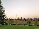
| Ada County, Boise
| 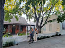
Cheryl and Simone by the Tree of Gernika, Boise. | Photographed 26 September 2022.
Location records that use this photograph:
Article records that use this photograph:
images/20220926_190813sm.jpg
| Bannock County
| 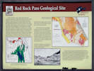
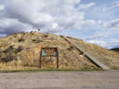
Interpretive Panel for Red Rock Pass | Photographed 21 October 2017.
Location records that use this photograph:
Article records that use this photograph:
images/IMGQ4431sm.jpg
| 
Looking north towards Zenda (in the trees) | Photographed 21 October 2017.
Location records that use this photograph:
Article records that use this photograph:
images/IMGQ4430sm.jpg
| 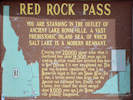
Interpretive Panel for Red Rock Pass | Photographed 21 October 2017.
Location records that use this photograph:
Article records that use this photograph:
images/IMGQ4432sm.jpg
| 
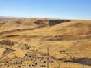
View from top of hill | Photographed 21 October 2017.
Location records that use this photograph:
Article records that use this photograph:
images/IMGQ4435sm.jpg
| 
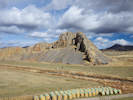
Hill with monument | Photographed 21 October 2017.
Location records that use this photograph:
Article records that use this photograph:
images/20171021_130110sm.jpg
| 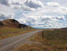
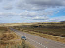
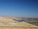
View south to Red Rock Pass | Photographed 21 October 2017.
Article records that use this photograph:
images/IMGQ4429sm.jpg
| 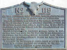
Memorial plaque to Captain Jefferson Hunt | Photographed 21 October 2017.
Location records that use this photograph:
Article records that use this photograph:
images/IMGQ4434sm.jpg
| Bannock County, Pocatello
| 
Brick 243 Gastropub and Thrive Artisanal Bowls and Wraps. | Photographed 3 October 2022. Where we had dinner in Pocatello.
Location records that use this photograph:
Article records that use this photograph:
images/20221003_180122sm.jpg
| Bingham County
| 
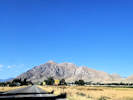
Middle Butte south of US Highway 20. | Photographed 3 September 2018.
Location records that use this photograph:
Article records that use this photograph:
images/20180903_175304sm.jpg
| 
East Butte south of US Highway 20. | Photographed 3 September 2018.
Location records that use this photograph:
Article records that use this photograph:
images/20180903_175618sm.jpg
| Bonneville County
| 
Angel Moroni watches over the Snake River. | Photographed 3 September 2018.
Location records that use this photograph:
Article records that use this photograph:
images/20180903_200555sm.jpg
| 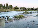
The falls at Idaho Falls | Photographed 3 September 2018.
Location records that use this photograph:
Article records that use this photograph:
images/20180903_200747sm.jpg
| 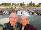
US at the falls. | Photographed 3 September 2018.
Location records that use this photograph:
Article records that use this photograph:
images/20180903_201509sm.jpg
| 
Snake River at Clark Hill Rest Area. | Photographed 4 September 2018.
Location records that use this photograph:
Article records that use this photograph:
images/20180904_091917sm.jpg
| Butte County
| 
Entry into Arco. | Photographed 3 September 2018.
Location records that use this photograph:
Article records that use this photograph:
images/20180903_172410sm.jpg
| 
Overlook of Craters of the Moon. | Photographed 3 September 2018.
Location records that use this photograph:
Article records that use this photograph:
images/20180903_163430sm.jpg
| 
Landscape of basalt volcanic field. | Photographed 3 September 2018.
Location records that use this photograph:
Article records that use this photograph:
images/20180903_163444sm.jpg
| 
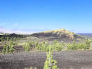
Number Hill in Arco. | Photographed 3 September 2018.
Location records that use this photograph:
Article records that use this photograph:
images/20180903_172417sm.jpg
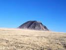
| 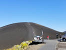
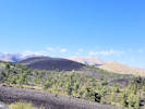
Inferno Cone. | Photographed 3 September 2018.
Location records that use this photograph:
Article records that use this photograph:
images/20180903_163434sm.jpg
| Godding County, Snake River
| 
The Snake River, upstream to the east. | Photographed 26 September 2022.
Location records that use this photograph:
Article records that use this photograph:
images/IMGQ5695sm.jpg
| 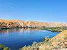
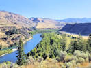
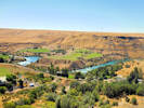
Snake River with Hagerman Fossil Beds beyond. | Photographed 26 September 2022.
Location records that use this photograph:
Article records that use this photograph:
images/20220926_130720sm.jpg
| 
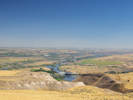
Valley of the Snake River, downstream. | Photographed 26 September 2022.
Location records that use this photograph:
Article records that use this photograph:
images/20220926_141227sm.jpg
| 
The Snake River, downstream (northwest). | Photographed 26 September 2022.
Location records that use this photograph:
Article records that use this photograph:
images/IMGQ5693sm.jpg
| 
Emigrant Trail from Overlook. | Photographed 26 September 2022.
Location records that use this photograph:
Article records that use this photograph:
images/20220926_133817sm.jpg
| 
Valley of the Snake River, just below the highway. | Photographed 26 September 2022.
Location records that use this photograph:
Article records that use this photograph:
images/20220926_141301sm.jpg
| 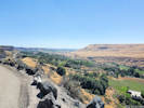
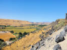
Valley of the Snake River, upstream. | Photographed 26 September 2022.
Location records that use this photograph:
Article records that use this photograph:
images/20220926_141248sm.jpg
| Gooding County, Hagerman Fossil Beds
| 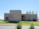
Visitor's Center for Thousand Springs State Park & Hagerman Fossil Beds National Monument. | Photographed 26 September 2022.
Location records that use this photograph:
Article records that use this photograph:
images/20220926_125022sm.jpg
| 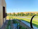
View of Hagerman Fossil Beds from window of Visitor's Center. | Photographed 26 September 2022.
Location records that use this photograph:
Article records that use this photograph:
images/20220926_124807sm.jpg
| Kootenai County
| 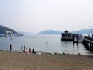
Lake Couer D'Alene. | Photographed 15 August 2018. It was really smoky.
Location records that use this photograph:
Article records that use this photograph:
images/20180815_141905sm.jpg
| Payette County
| 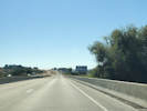
Welcome to Idaho. | Photographed 3 October 2022.
Article records that use this photograph:
images/20221003_120908sm.jpg
|
| Date and time this article was prepared: 4/27/2024 3:34:45 PM | |||||||||||||