
Eastern Mojave Vegetation
By Tom Schweich
 Eastern Mojave Vegetation | Images -- Botany |
|
By Tom Schweich |
|

Unclassified Geography - Idaho Geography - Park County, CO Geography - Summit County, CO Geography - Arizona Geography - British Columbia Geography - California Geography - California's Colorado Desert Alaska Geography - Mono Lake Basin, California Geography - Mono County, California Geography - San Luis Obispo County, California Geography - Marin County, California Geography - Santa Clara County Alameda Garden Geography - Central Mojave Geography - New Mexico Geography - Eastern Mojave Geography - Northern Mojave Geography - Colorado Geography - Alamosa County, CO Geography - Boulder County, CO Geography - Clear Creek County, CO Geography - Chaffee County, CO Geography - Douglas County, CO Geography - Gilpin County, CO Geography - Golden, Colorado Geography - Weld County, CO Geography - Hinsdale County, CO Geography - Jefferson County, CO Geography - North Table Mountain, Jefferson Cty, CO Geography - Lake County, CO Geography - Larimer County, CO Geography - Nevada Geography - Oregon Geography - South Dakota Geography - Utah Geography - Virginia Geography - Washington Geography - Wyoming Spain - Andalucia Spain - Castilla y Leon Spain - Castilla-La Mancha Spain - Extremadura Spain - Galicia Spain - Madrid Portugal Geology Economic Geology Climatology Botany Salvia dorrii Frasera albomarginata Species Species - Polygonaceae Species - Brassicaceae Species - Brassicaceae, Physaria vitulifera Species - Rosaceae Species - Fabaceae Species - Onagraceae Species - Polemoniaceae Species - Boraginaceae Species - Plantaginaceae Species - Asteraceae Species - Poaceae Zoology Ecology Archeology Customer Satisfaction General Arizona California Kansas Missouri Nebraska New York Christmas 2002 Family Photos Family Documents Family Photos 2003 Art of Lydia Schweich Portraits Railroad Geography - Germany |
Images are organized by the topics listed at left. Click on a topic name to see images with that topic. Would you like to use these photographs in your school term paper or report? License is hereby granted for non-commercial use of the images contained herein provided that the images are reproduced with the copyright notice intact. This means that we give you our permission to use the photographs and information you find here in your school term papers and reports. You may resize the photograph to fit your needs, but you may not remove the copyright. Your term paper should note that the photographs are reproduced with permission and it should have a reference to this web site, such as: "Photograph ©1999 Tom Schweich. Used by permission, http://www.schweich.com" If you have a comment or a question about a photograph you may write to me at tomas@schweich.com I will answer you as soon as I can. I sometimes post interesting questions in my FAQ, but I will not disclose your full name or address.
| Anatomy
| 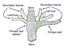
Node anatomy of S. dorrii. | One fine spring afternoon I sat in my lawn chair at the Bonanza King Mine. Examining a moderate sized shrub I noticed that the primary leaves at some of the nodes were starting to fall off leaving smaller secondary leaves behind. At this node that I sketched, one primary leaf had fallen off, while the other remained. I noticed also that there were new leaves growing at each node.
Article records that use this photograph:
images/saldornode.gif
| Climax Vegetation
| 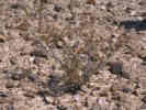
Climax vegetation on Harvard Hill. | The only plants gowing here in the dry spring of 2002 were these small, pitiful Creosote bushes (Larrea tridentats).
Location records that use this photograph:
Article records that use this photograph:
images/1339_3153_1142_05sm.jpg
| DeCandolle 1857 Signorum Prodromi Explicatio
| 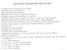
Signs in the Prodromo Explained | Table in DeCandolle (1857), unnumbered page at beginning of document, URL = https://www.biodiversitylibrary.org/item/109211#page/6/
Article records that use this photograph: images/DeCandolle1857_SPE.jpg
| Vegetation
| 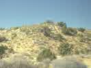
Vegetation along Wild Horse Canyon Road, in the head of Macedonia Canyon. | The large dark gray bushes in the foreground wash are Desert Almond (Prunus fasciculata). There are Utah Junipers (Juniperus osteosperma) and a few Singleleaf Pinyons (Pinus monophylla) on the slopes above the wash, but no Joshua Trees (Yucca brevifolia) are found at this location on the southeast slope of the Mid Hills. Difficult to see in the picture, but nevertheless still there, are numerous Blue Yucca (Yucca Baccata) and Mohave Yucca (Y. schidigera) growing together.
Article records that use this photograph:
images/maccynhill.jpg
| 
Yellow composites among the Basin Sagebrush (Artemisia tridentata) in the Nelson Range. |
Article records that use this photograph:
images/nelsonyellow.jpg
| 
Vegetation along Cedar Canyon Road. | Cedar Canyon Road is the upper portion of the elevational gradient studied by Yeaton, et al. (1985). This little valley south of Cedar Canyon Road is at 1525 m elevation, the elevation of the next-to-highest of Yeaton, et al.'s (1985) plots.
Article records that use this photograph:
images/cedarveges.jpg
| 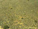
Photograph of the base vegetation in the vicinity of Lobo Point. | I took this photograph from a rim of Peach Springs Tuff, just north of Lobo Point. The road to Lobo Point can just barely be seen in the extreme lower left corner of the photograph. The large green bushes are Utah Junipers (Juniperus osteosperma). The dark gray bushes are Blackbrush (Coleogyne ramosissima). The silvery gray bushes are Salvia dorrii or Salazaria mexicana, and the brownish bushes are California Buckwheat (Eriogonum fasciculatum).
images/vegetype.jpg
| 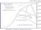
Relative proportion of types of vegetation by elevation in the vicinity of Lobo Point and the Mid Hills. | This diagram is drawn from my subjective analysis of the type of vegetation by elevation within the Columbia Mountain quadrangle. Also subjective is the classinfication of vegetation into types. For example, any vegetation that contains Joshua Trees (Yucca brevifolia) is likely to be subjectively classified as Joshua Tree woodland, even though any objective measurement would show that the Joshua Trees formed only a small part of the biomass.
Article records that use this photograph:
images/ColumbiaMtnVegetationDrawing.jpg
| 
Scene along Wild Horse Canyon Road near Mid Hills campground. | Large rounded outcrops of granite are visible through the Singleleaf Pinyons (Pinus monophylla). In the left foreground is the yellowish green of Green Ephedra (Ephedra viridis), and in the right foreground is the dark green foliage of Waxy Bitterbrush (Purshia tridentata var. glandulosa).
Article records that use this photograph:
images/midhillscene.jpg
| 
Relative proportion of types of vegetation by elevation in the vicinity of Lobo Point and the Mid Hills. | This diagram is drawn from my subjective analysis of the type of vegetation by elevation within the Columbia Mountain quadrangle. Also subjective is the classinfication of vegetation into types. For example, any vegetation that contains Joshua Trees (Yucca brevifolia) is likely to be subjectively classified as Joshua Tree woodland, even though any objective measurement would show that the Joshua Trees formed only a small part of the biomass.
Article records that use this photograph:
images/tranplus.gif
| 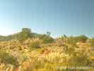
Vegetation along the Mid Hills ridgeline. | General view of vegetation along the Mid Hills ridgeline between Macedonia Canyon and Silver Lead Spring. A few Joshua trees (Yucca brevifolia) grow on the ridgeline and a little to the southwest, but this is the southwestern limit of Joshua trees in the Mid Hills. Columbia Mountain, namesake of the U.S.G.S. quadrangle, can be seen behind the pinyon (Pinus monophylla) on the ridgeline.
Article records that use this photograph:
images/midhilveg.jpg
| 
Density and coverage |
Article records that use this photograph:
images/denandcov.gif
| 
Portion of transect data sheet. |
Article records that use this photograph:
images/lppjgrid_tr960429.gif
| 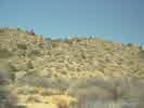
Vegetation along Wild Horse Canyon Road, in the head of Macedonia Canyon. | The large dark gray bushes in the foreground wash are Desert Almond (Prunus fasciculata), and the smaller yellowish bushes are Sticky Snakeweed (Gutierrezia microcephala). There are Utah Junipers (Juniperus osteosperma) and a few Singleleaf Pinyons (Pinus monophylla) on the slopes above the wash, but no Joshua Trees (Yucca brevifolia) are found at this location on the southeast slope of the Mid Hills.
Article records that use this photograph:
images/hdmacecyn.jpg
| 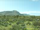
Vegetation near Hole-in-the-Wall. | As you can see, this picture was taken in an unusually green Spring. The cactus in the foreground is Buckhorn Cholla (Opuntia acanthocarpa). The large tree-like plants are Mohave Yucca (Yucca schidigera). The smaller shrubs are boxthorns (Lycium sp.), Blackbrush (Coleogyne ramosissima), and Great Basin Blue Sage (Salvia dorrii).
Article records that use this photograph:
images/veghith.jpg
| Vegetation, Blackbrush
| 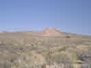
Blackbrush Scrub along Black Canyon Road. | This view looks northwest toward Gold Valley Mine and the Little Thorn Mountains. This is one location in the Eastern Mojave where Blackbrush (Coleogyne ramosissima>) reaches its maximum dominance. Realtive density of Blackbrush is about 70% at this location.
Article records that use this photograph:
images/gvbb.jpg
|
| Date and time this article was prepared: 4/21/2025 8:32:27 PM | |||||