
Eastern Mojave Vegetation
By Tom Schweich
|
Eastern Mojave Vegetation | Images -- Geography - Mono County, California |
|
By Tom Schweich |
|

Unclassified Geography - Idaho Geography - Park County, CO Geography - Summit County, CO Geography - Arizona Geography - British Columbia Geography - California Geography - California's Colorado Desert Alaska Geography - Mono Lake Basin, California Geography - Mono County, California Geography - San Luis Obispo County, California Geography - Marin County, California Geography - Santa Clara County Alameda Garden Geography - Central Mojave Geography - New Mexico Geography - Eastern Mojave Geography - Northern Mojave Geography - Colorado Geography - Alamosa County, CO Geography - Boulder County, CO Geography - Clear Creek County, CO Geography - Chaffee County, CO Geography - Douglas County, CO Geography - Gilpin County, CO Geography - Golden, Colorado Geography - Weld County, CO Geography - Hinsdale County, CO Geography - Jefferson County, CO Geography - North Table Mountain, Jefferson Cty, CO Geography - Lake County, CO Geography - Larimer County, CO Geography - Nevada Geography - Oregon Geography - South Dakota Geography - Utah Geography - Virginia Geography - Washington Geography - Wyoming Spain - Andalucia Spain - Castilla y Leon Spain - Castilla-La Mancha Spain - Extremadura Spain - Galicia Spain - Madrid Portugal Geology Economic Geology Climatology Botany Salvia dorrii Frasera albomarginata Species Species - Polygonaceae Species - Brassicaceae Species - Brassicaceae, Physaria vitulifera Species - Rosaceae Species - Fabaceae Species - Onagraceae Species - Polemoniaceae Species - Boraginaceae Species - Plantaginaceae Species - Asteraceae Species - Poaceae Zoology Ecology Archeology Customer Satisfaction General Arizona California Kansas Missouri Nebraska New York Christmas 2002 Family Photos Family Documents Family Photos 2003 Art of Lydia Schweich Portraits Railroad Geography - Germany |
Images are organized by the topics listed at left. Click on a topic name to see images with that topic. Would you like to use these photographs in your school term paper or report? License is hereby granted for non-commercial use of the images contained herein provided that the images are reproduced with the copyright notice intact. This means that we give you our permission to use the photographs and information you find here in your school term papers and reports. You may resize the photograph to fit your needs, but you may not remove the copyright. Your term paper should note that the photographs are reproduced with permission and it should have a reference to this web site, such as: "Photograph �1999 Tom Schweich. Used by permission, http://www.schweich.com" If you have a comment or a question about a photograph you may write to me at tomas@schweich.com I will answer you as soon as I can. I sometimes post interesting questions in my FAQ, but I will not disclose your full name or address.
| 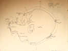
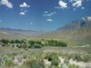
Sketch map of Mono Basin Research Group sites. |
Location records that use this photograph:
Article records that use this photograph:
images/MBRGSketchMap.jpg
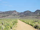
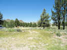
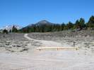
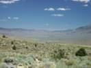
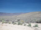
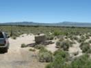
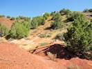
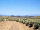
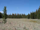
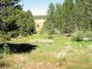
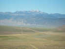
| "Airfield Flat"
| 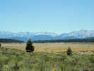
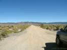
Airfield Flat, as seen from north to south. | Photograph taken 16 August 2010. The airfield runs north and south on the west side of the flat, i.e., in the right side of the photo.
Location records that use this photograph:
Article records that use this photograph:
images/IMG_1288sm.jpg
| 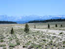
Airfield in unnamed flat near Deadman Summit. | Photograph taken 16 August 2010.
Location records that use this photograph:
Article records that use this photograph:
images/IMG_1293sm.jpg
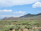
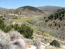
| Adobe Hills
| 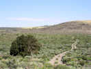
View to the northwest, along the route of 01N112. | Photograph taken 29 June 2010.
Location records that use this photograph:
Article records that use this photograph:
images/IMG_0949sm.jpg
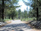
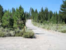
| 
The southern end of Dobie Meadows Road. | Photograph taken 23-Sep-06.
Location records that use this photograph:
Article records that use this photograph:
images/IMG_0764sm.jpg
| Adobe Hills Spillway
| 
Adobe Hills Spillway from the south, | Photograph taken 23-Sep-06. Water from Lake Russell (Mono Lake) would flow over the spillway toward to viewer.
Location records that use this photograph:
Article records that use this photograph:
images/IMG_0770sm.jpg
| 
Adobe Hills Spillway from Cowtrack Mountain | Photograph taken 25-Jun-07. The Adobe Hills Spillway is circled in red. The Mono Basin is to the left, or north of the spillway. The right, or south side, drains first to Adobe Valley, then the Chalfant Valley, and finally the Owens Valley.
Location records that use this photograph:
Article records that use this photograph:
images/IMGP2684sm.jpg
| 
Looking downstream from the spillway. | Photograph taken 23-Sep-06. Water from Lake Russell (Mono Lake) would flow away from the viewer into Adobe Valley.
Location records that use this photograph:
Article records that use this photograph:
images/IMG_0774sm.jpg
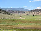
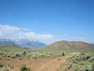
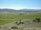
| Adobe Valley
| 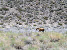
Wild horse in Adobe Valley. | Photograph taken July 7, 2009.
Article records that use this photograph:
images/IMG01978sm.jpg
| 
Looking into Adobe Valley. | Photograph taken 23-Sep-06 from the entrance to the canyon on Dobie Meadows Road.
Article records that use this photograph: images/IMG_0768sm.jpg
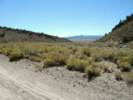
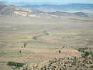
| 
Looking out of Mono Basin into Adobe Valley drainage. | Photograph taken 23 July 2010.
Article records that use this photograph:
images/IMG_1083sm.jpg
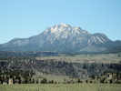
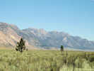
| 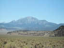
Glass Mountain from Adobe Valley | Photograph taken July 7, 2009.
Location records that use this photograph:
Article records that use this photograph:
images/IMG01979sm.jpg
| 
View north on Dobie Meadows Road. | Photograph taken 28 June 2010.
Article records that use this photograph:
images/IMG_0945sm.jpg
| 
California Highway 120 southeast towards the White Mountains. | Photograph taken 23-Sep-06 at the intersection with Dobie Meadows Road.
Location records that use this photograph:
Article records that use this photograph:
images/IMG_0766sm.jpg
| 
California Highway 120 begins climbing out of Adobe Valley. | Photograph taken 23-Sep-06 at the intersection with Dobie Meadows Road.
Article records that use this photograph:
images/IMG_0765sm.jpg
| 
View of Johnny Meadow | Photograph taken 21 June 2010.
Location records that use this photograph:
Article records that use this photograph:
images/IMG_0921sm.jpg
| 
Earthscope GPS station near Sagehen Meadow. | Photograph taken 21 June 2010. I think this is Station P641.
Article records that use this photograph:
images/IMG_0914sm.jpg
| 
Sagehen Meadow Campground | Photograph taken July 7, 2009.
Location records that use this photograph:
Article records that use this photograph:
images/IMG01982sm.jpg
| 
Lower end of Taylor Canyon | Photograph taken 7 August 2010.
Article records that use this photograph:
images/IMG_1238.jpg
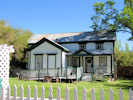
| 
For Sale sign on House and Land in Dexter Canyon | Photograph taken 7 August 2010.
Article records that use this photograph:
images/IMG_1239sm.jpg
| 
View into Adobe Valley drainage from Sagehen Meadow Road. | Photograph taken 23 July 2010.
Article records that use this photograph:
images/IMG_1077sm.jpg
| 
House for sale, 200 ac., 2 bdrm, 2 1/2 million. | Photograph taken 7 August 2010.
Article records that use this photograph:
images/IMG_1241sm.jpg
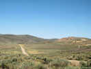
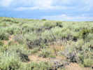
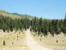
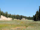
| Airfield Flat
| 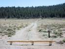
x-Forest Road 2S259 to the northeast | Photographed 30 May 2012.
Article records that use this photograph:
images/IMG30211sm.jpg
| 
x-Forest Road 2S259 to the west | Photographed 30 May 2012.
Article records that use this photograph:
images/IMG30209sm.jpg
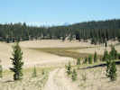
| 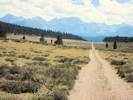
Looking south through Airfield Flat | Photographed 25 August 2012.
Location records that use this photograph:
Article records that use this photograph:
images/IMG30659sm.jpg
| Arborglyphs
| 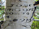
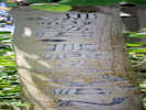
Arborglyph on Sagehen Meadows Road | Photograph taken June 22, 2010. This one says, �Jose Irigoyen, Agosto 4, 1970.�
Article records that use this photograph:
images/IMG_0916sm.jpg
| 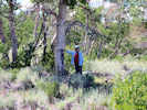
Cheryl by arborglyphs beside Sagehen Meadow Road. | Photograph taken 15 Jul 2010.
Article records that use this photograph:
images/IMGP0482sm.jpg
| 
A particularly elaborate arborglyph. | Photograph taken 15 July 2010.
Article records that use this photograph:
images/IMGP0480sm.jpg
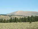
| Bald Mountain
| 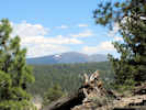
View of Bald Mountain, southeast of Mono Craters. | Photograph taken 15 June 2011.
Location records that use this photograph:
Article records that use this photograph:
images/IMG11901sm.jpg
| Bennettville
| 
Bennettville and Tioga Peak from the dump of the adit. | Photograph taken 24-Jun-07.
Location records that use this photograph:
Article records that use this photograph:
images/IMG_1725sm.jpg
| 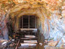
Inside the adit of the Great Sierra Consolidated Silver Company at Bennettville | Photograph taken 24-Jun-07.
Location records that use this photograph:
Article records that use this photograph:
images/IMG_1721sm.jpg
| 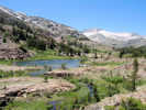
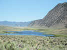
Mine Creek and Shell Lake | Photograph taken 24-Jun-07. The lake is Shell Lake, and Mine Creek is coming toward the viewer on its way to join upper Lee Vining Creek at Junction Campground. The peak in the right distance is Mount Conness.
Location records that use this photograph:
Article records that use this photograph:
images/IMG_1718sm.jpg
| 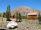
Bennettville and Tioga Peak | Photograph taken 24-Jun-07. The two cabins are at the Bennettville site. Tioga Peak in the background.
Location records that use this photograph:
Article records that use this photograph:
images/IMG_1715sm.jpg
| 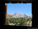
Mount Dana from Bennettville | Photograph taken 24-Jun-07.
Location records that use this photograph:
Article records that use this photograph:
images/IMG_1709sm.jpg
| 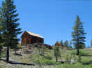
Two cabins at Bennettville | Photograph taken 24-Jun-07.
Location records that use this photograph:
Article records that use this photograph:
images/IMG_1702sm.jpg
| 
Adit of the Great Sierra Consolidated Silver Company at Bennettville | Photograph taken 24-Jun-07. This adit was driven 1,800 feet without encountering ore of any particular value.
Location records that use this photograph:
Article records that use this photograph:
images/IMG_1720sm.jpg
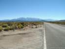
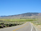
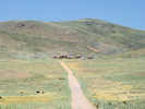
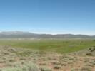
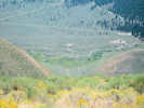
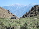
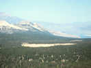
| Benton and vicinity
| 
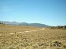
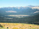
Looking toward Montgomery Pass through Benton Valley. | Photograph taken July 17, 2005. US Highway 6 is in the valley, and the White Mountains are at right.
Location records that use this photograph:
Article records that use this photograph:
images/IMGP1645sm.jpg
| 
View of the Benton Hot Springs Ranch meadow. | Photograph taken 26 June 2010.
Article records that use this photograph:
images/IMG_0935sm.jpg
| 
Bed and breakfast at Benton Hot Springs | Photograph taken 27 June 2010.
Location records that use this photograph:
Article records that use this photograph:
images/IMG_0937sm.jpg
| 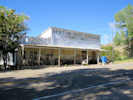
Stage station in Benton Hot Springs | Photograph taken 27 June 2010.
Location records that use this photograph:
Article records that use this photograph:
images/IMG_0936sm.jpg
| 
Looking south in the meadow near Benton Hot Springs | Photograph taken 26 June 2010.
Location records that use this photograph:
Article records that use this photograph:
images/IMG_0932sm.jpg
| 
Benton Hot Springs. | Photograph taken July 17, 2005.
Location records that use this photograph:
Article records that use this photograph:
images/IMGP1641asm.jpg
| Benton Valley
| 
Surface expression of Queen Valley Thrust Fault. | Photographed 22 June 2015.
Location records that use this photograph:
Article records that use this photograph:
images/IMGQ0972sm.jpg
| Bodie
| 
Bodie | Photograph taken 26-Jun-07.
Location records that use this photograph:
Article records that use this photograph:
images/IMGP2701sm.jpg
| 
Bodie from the South | Photograph taken 26-Jun-07.
Location records that use this photograph:
Article records that use this photograph:
images/IMG_1822sm.jpg
| Bodie & Benton Railroad
| 
Crossing of the Bodie and Benton Railroad | Photograph taken 5-Jun-06.
Article records that use this photograph:
images/IMG_0484sm.jpg
| Bodie Hills
| 
Small lightning set fires in the Bodie Hills. | Photograph taken 25 July 2010 from California Highway 270 north of Mt. Biedeman.
Article records that use this photograph:
images/IMG01106sm.jpg
| 
Small exclosure in Bodie Hills. | Photograph taken 25 July 2010 in the Bodie Hills, northeast of Mt. Biedeman and south of California Highway 270.
Article records that use this photograph:
images/IMG_1104sm.jpg
| 
Looking west into Clearwater Creek (East Walker River) Drainage | Photograph taken 25 July 2010.
Article records that use this photograph:
images/IMG_1094sm.jpg
| 
Outcrop near Coyote Springs Road. | Photographed 24 August 2012.
Location records that use this photograph:
Article records that use this photograph:
images/IMG30634sm.jpg
| Bridgeport
| 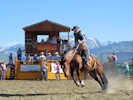
Bridgeport Ranch Rodeo | Photograph taken 4 July 2010
Location records that use this photograph:
Article records that use this photograph:
images/IMG_1017sm.jpg
| 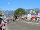
Independence Day parade in Bridgeport | Photograph taken 4 July 2010
Location records that use this photograph:
Article records that use this photograph:
images/IMG_0972sm.jpg
| Bridgeport Canyon
| 
Horses in pass of Bridgeport Canyon | Photograph taken 26-Jun-07. This photo looks west in the pass at the head of Bridgeport Canyon. The folks with the horses were living in a trailer.
Location records that use this photograph:
Article records that use this photograph:
images/IMG_1809sm.jpg
| 
The road ahead: looking into the Walker River watershed. | Photograph taken 26-Jun-07. This photo looks north into the Clearwater Creek drainage and therefore into the Walker River basin.
Location records that use this photograph:
Article records that use this photograph:
images/IMG_1810sm.jpg
| Bridgeport Valley
| 
Panorama of Bridgeport Valley | Photograph taken 4-Jun-06. At the extreme right is the Bridgeport Remote Automated Weather Station (RAWS). Current data is available from: http://raws.wrh.noaa.gov/cgi-bin/roman/meso_base.cgi?stn=BPOC1.
Location records that use this photograph:
Article records that use this photograph:
images/IMG_0454-8c.jpg
| 
Bridgeport Valley, just west of Bridgeport | Photograph taken 4-Jun-06.
Location records that use this photograph:
Article records that use this photograph:
images/IMG_0460sm.jpg
| Californa, Mono County
| 
Wild Horse Meadow from Sagehen Peak | Photograph taken August 13, 2008.
Location records that use this photograph:
Article records that use this photograph:
images/IMG01319sm.jpg
| 
Glass Mountain from Sagehen Peak | Photograph taken August 13, 2008.
Location records that use this photograph:
Article records that use this photograph:
images/IMG01320sm.jpg
| 
Dexter Canyon from Sagehen Peak | Photograph taken August 13, 2008.
Location records that use this photograph:
Article records that use this photograph:
images/IMG01321sm.jpg
| 
Glass Mountain from California Highway 120 near Granite Mountain | Photograph taken June 12, 2008.
Location records that use this photograph:
Article records that use this photograph:
images/IMG01073sm.jpg
| 
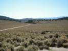
Unnamed sand flat south of Bald Mountain Road. | Photograph taken August 13, 2008.
Location records that use this photograph:
Article records that use this photograph:
images/IMG01284sm.jpg
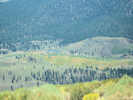
| 
McLaughlin Creek watershed | Photograph taken August 13, 2008.
Location records that use this photograph:
Article records that use this photograph:
images/IMG01307sm.jpg
| 
Sagehen Peak, California, from California Highway 120. | Photograph taken June 12, 2008.
Location records that use this photograph:
Article records that use this photograph:
images/IMG01072sm.jpg
| 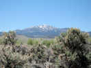
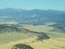
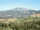
Glass Mountain from Adobe Valley, California. | Photograph taken June 12, 2008.
Location records that use this photograph:
Article records that use this photograph:
images/IMG01071sm.jpg
| 
Black Lake alongside California Highway 120 | Photograph taken June 12, 2008.
Location records that use this photograph:
Article records that use this photograph:
images/IMG01069sm.jpg
| 
Deadman Creek basin from Bald Mountain, California | Photograph taken August 13, 2008. I don't think this basin has a name, but Deadman Creek runs through it in the direction toward the viewer. The mountains around the northwest corner of the basin look to me as though they may form the northwest wall of the Long Valley Caldera.
Location records that use this photograph:
Article records that use this photograph:
images/IMG01285sm.jpg
| 
Crooked Meadows from the north. | Photograph taken August 13, 2008.
Location records that use this photograph:
Article records that use this photograph:
images/IMG01306sm.jpg
| 
Owens River from Bald Mountain | Photograph taken August 13, 2008.
Location records that use this photograph:
Article records that use this photograph:
images/IMG01294sm.jpg
| 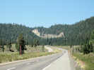
US Highway 395 just south of Crestview and Deadman Summit | Photograph taken August 14, 2008.
Article records that use this photograph:
images/IMG01350sm.jpg
| 
Owens River from Bald Mountain | Photograph taken August 13, 2008.
Location records that use this photograph:
Article records that use this photograph:
images/IMG01295sm.jpg
| 
Crooked Meadows Campground | Photograph taken August 13, 2008.
Location records that use this photograph:
Article records that use this photograph:
images/IMG01311sm.jpg
| 
Crooked Meadows | Photograph taken August 13, 2008.
Location records that use this photograph:
Article records that use this photograph:
images/IMG01308sm.jpg
| 
Wild Horse Meadow | Photograph taken August 13, 2008.
Location records that use this photograph:
Article records that use this photograph:
images/IMG01312sm.jpg
| 
Road Intersection | Photograph taken August 13, 2008.
Article records that use this photograph:
images/IMG01269sm.jpg
| 
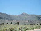
Glass Mountain, northeast wall of Long Valley Caldera | Photograph taken August 14, 2008.
Location records that use this photograph:
Article records that use this photograph:
images/IMG01349sm.jpg
| 
Crooked Meadows Spring | Photograph taken August 13, 2008.
Location records that use this photograph:
Article records that use this photograph:
images/IMG01310sm.jpg
| 
Obsidian flow to west of US Highway 395 | Photograph taken August 14, 2008.
Article records that use this photograph:
images/IMG01351sm.jpg
| 
Bald Mountain from US Highway 395 | Photograph taken August 14, 2008.
Location records that use this photograph:
Article records that use this photograph:
images/IMG01352sm.jpg
| 
Water gap in lower Adobe Valley | Photograph taken June 12, 2008.
Article records that use this photograph:
images/IMG01068sm.jpg
| 
Little Sand Flat from Bald Mountain, California | Photograph taken August 13, 2008. Mono Craters in left middleground, and Mono Lake can just be seen in lower right.
Location records that use this photograph:
Article records that use this photograph:
images/IMG01283sm.jpg
| 
Glass Mountain across Queen Valley | Photograph taken June 12, 2008.
Location records that use this photograph:
Article records that use this photograph:
images/IMG01067sm.jpg
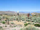
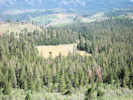
| Cinnabar Canyon
| 
View from quarry in Cinnabar Canyon | Photograph taken 26-Jun-07.
Location records that use this photograph:
Article records that use this photograph:
images/IMG_1838sm.jpg
| | |||||||||||||||||||