
Eastern Mojave Vegetation
By Tom Schweich
|
Eastern Mojave Vegetation | Images -- Geography - Arizona |
|
By Tom Schweich |
|

Unclassified Geography - Idaho Geography - Park County, CO Geography - Summit County, CO Geography - Arizona Geography - British Columbia Geography - California Geography - California's Colorado Desert Alaska Geography - Mono Lake Basin, California Geography - Mono County, California Geography - San Luis Obispo County, California Geography - Marin County, California Geography - Santa Clara County Alameda Garden Geography - Central Mojave Geography - New Mexico Geography - Eastern Mojave Geography - Northern Mojave Geography - Colorado Geography - Alamosa County, CO Geography - Boulder County, CO Geography - Clear Creek County, CO Geography - Chaffee County, CO Geography - Douglas County, CO Geography - Gilpin County, CO Geography - Golden, Colorado Geography - Weld County, CO Geography - Hinsdale County, CO Geography - Jefferson County, CO Geography - North Table Mountain, Jefferson Cty, CO Geography - Lake County, CO Geography - Larimer County, CO Geography - Nevada Geography - Oregon Geography - South Dakota Geography - Utah Geography - Virginia Geography - Washington Geography - Wyoming Spain - Andalucia Spain - Castilla y Leon Spain - Castilla-La Mancha Spain - Extremadura Spain - Galicia Spain - Madrid Portugal Geology Economic Geology Climatology Botany Salvia dorrii Frasera albomarginata Species Species - Polygonaceae Species - Brassicaceae Species - Brassicaceae, Physaria vitulifera Species - Rosaceae Species - Fabaceae Species - Onagraceae Species - Polemoniaceae Species - Boraginaceae Species - Plantaginaceae Species - Asteraceae Species - Poaceae Zoology Ecology Archeology Customer Satisfaction General Arizona California Kansas Missouri Nebraska New York Christmas 2002 Family Photos Family Documents Family Photos 2003 Art of Lydia Schweich Portraits Railroad Geography - Germany |
Images are organized by the topics listed at left. Click on a topic name to see images with that topic. Would you like to use these photographs in your school term paper or report? License is hereby granted for non-commercial use of the images contained herein provided that the images are reproduced with the copyright notice intact. This means that we give you our permission to use the photographs and information you find here in your school term papers and reports. You may resize the photograph to fit your needs, but you may not remove the copyright. Your term paper should note that the photographs are reproduced with permission and it should have a reference to this web site, such as: "Photograph �1999 Tom Schweich. Used by permission, http://www.schweich.com" If you have a comment or a question about a photograph you may write to me at tomas@schweich.com I will answer you as soon as I can. I sometimes post interesting questions in my FAQ, but I will not disclose your full name or address.
| 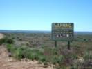
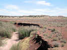
Warning sign on Mt. Trumbull Road. | Photograph taken May 31, 2005.
Article records that use this photograph:
images/IMGP1344sm.jpg
| 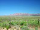
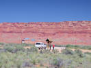
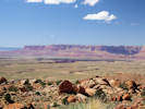
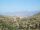
Vermilion Cliffs as seen from Mt. Trumbull Loop Road, near Pipe Springs, AZ | Photograph taken May 31, 2005.
Location records that use this photograph:
Article records that use this photograph:
images/IMGP1345sm.jpg
| Apache County
| 
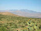
View southeast toward Alpine. | Photograph taken June 2, 2008.
Location records that use this photograph:
Article records that use this photograph:
images/IMG_0755sm.jpg
| 
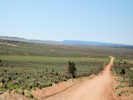
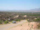
Countryside west of Alpine, Arizona | Photograph taken June 2, 2008.
Location records that use this photograph:
Article records that use this photograph:
images/IMG00756sm.jpg
| 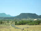
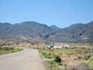
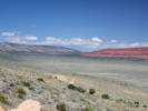
Countryside northwest of Springerville. | Photograph taken June 2, 2008.
Location records that use this photograph:
Article records that use this photograph:
images/IMG00757sm.jpg
| 
Little Colorado River | Photograph taken June 2, 2008.
Location records that use this photograph:
Article records that use this photograph:
images/IMG_0759sm.jpg
| 
Hubbell Trading Post National Historic Site | Photograph taken June 2, 2008.
Location records that use this photograph:
Article records that use this photograph:
images/IMG00768sm.jpg
| 
Area of Teec Nos Pos, Arizona | Photograph taken June 3, 2008.
Location records that use this photograph:
Article records that use this photograph:
images/IMG00779sm.jpg
| Arizona, Mohave County
| 
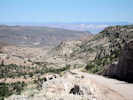
Looking toward Wolf Hole from Mokaac Pass, Arizona | Photograph taken June 9, 2008.
Location records that use this photograph:
Article records that use this photograph:
images/IMG00951sm.jpg
| 
Quail Hill above the Mt Trumbull Loop Road | Photograph taken June 9, 2008. I walked up here looking for Frasera albomarginata.
Location records that use this photograph:
Article records that use this photograph:
images/IMG00945sm.jpg
| 
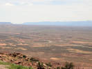
Looking north toward St. George, Utah | Photograph taken June 9, 2008.
Article records that use this photograph:
images/IMG00952sm.jpg
| 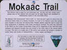
Sign along the Mokaac Trail | Photograph taken June 9, 2008.
Article records that use this photograph:
images/IMG00944sm.jpg
| Bitter Springs
| 
Bitter Springs from the scenic viewpoint. | Photographed 19 April 2017.
Location records that use this photograph:
Article records that use this photograph:
images/IMGQ3836sm.jpg
| Canyon de Chelly
| 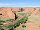
View of Canyon de Chelly from the south rim. | Photograph taken June 2, 2008.
Location records that use this photograph:
Article records that use this photograph:
images/IMG_0777sm.jpg
| Cochise County
| 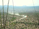
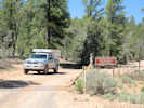
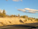
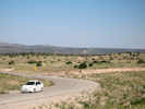
Truck speeds along 3 Links Road. | Photograph taken June 1, 2008.
Article records that use this photograph:
images/IMG_0729sm.jpg
| 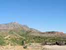
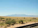
Johnson Mine and Little Dragoon Mountains | Photograph taken June 1, 2008.
Location records that use this photograph:
Article records that use this photograph:
images/IMG00721sm.jpg
| 
Intersection of Cascabel and Three Links Roads | Photograph taken June 1, 2008.
Article records that use this photograph:
images/IMG_0725sm.jpg
| 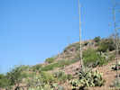
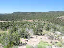
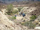
Vegetation at summit of 3 Links Road | Photograph taken June 1, 2008.
Article records that use this photograph:
images/IMG_0727sm.jpg
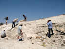
| 
Vegetation at summit of 3 Links Road | Photograph taken June 1, 2008.
Article records that use this photograph:
images/IMG_0728sm.jpg
| 
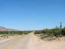
Looking south toward Benson from Cascabel Road | Photograph taken June 1, 2008.
Article records that use this photograph:
images/IMG_0724sm.jpg
| Cochise County, Cascabel
| 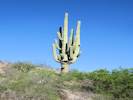
Giant saguaro beside Cascabel Road. | Photograph taken 26 April 2011.
Article records that use this photograph:
images/IMG_1693sm.jpg
| Coconino County
| 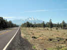
San Francisco Peaks from US Highway 180. | Photograph taken May 31, 2008.
Article records that use this photograph:
images/IMG_0714sm.jpg
| Colorado River
| 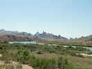
The Needles from Topock, Arizona | Photograph taken May 29, 2008.
Location records that use this photograph:
Article records that use this photograph:
images/IMG_0675sm.jpg
| Coyote Valley
| 
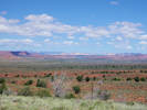
Coyote Valley between Buckskin Mountain on the left (west) and the Paria Plateau on the right (east). | Photographed 19 April 2017.
Article records that use this photograph:
images/IMGQ3820sm.jpg
| Graham County
| 
US Highway 191 north from US I-10. | Photograph taken June 1, 2008.
Article records that use this photograph:
images/IMG_0734sm.jpg
| Grand Canyon
| 
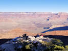
At Desert View | Photographed 24 November 2019.
Location records that use this photograph:
Article records that use this photograph:
images/20191124_132522sm.jpg
| 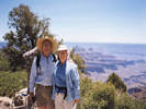
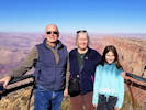
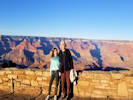
Cheryl and Tom at the North Rim of the Grand Canyon. | Photographed in May 1998.
Location records that use this photograph:
Article records that use this photograph: images/199805NN_GRCA_North_Rimsm.jpg
| 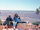
Jacob, Cheryl, and Rachel on the rim of the Grand Canyon. | Photographed in May 1987.
Location records that use this photograph:
Article records that use this photograph:
images/8751_img175sm.jpg
| 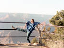
Rachel hangs on the fence at Grand Canyon. | Photographed in May 1987.
Location records that use this photograph:
Article records that use this photograph:
images/8751_img170sm.jpg
| 
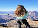
Beyond the rail at Grand Canyon. | Photographed 24 November 2019.
Article records that use this photograph:
images/20191124_153250sm.jpg
| 
Sofia at Grandview Point | Photographed 24 November 2019.
Location records that use this photograph:
Article records that use this photograph:
images/20191124_140644sm.jpg
| 
At Grand Canyon | Photographed 24 November 2019.
Location records that use this photograph:
Article records that use this photograph:
images/20191124_162357sm.jpg
| 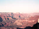
Grand Canyon in the evening. | Photographed in May 1987.
Location records that use this photograph:
Article records that use this photograph:
images/8751_img169sm.jpg
| 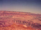
Grand Canyon in the evening. | Photographed in May 1987.
Location records that use this photograph:
Article records that use this photograph:
images/8751_img171sm.jpg
| 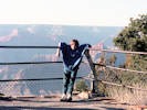
Rachel hangs on the fence at Grand Canyon. | Photographed in May 1987.
Article records that use this photograph:
images/8751_img168sm.jpg
| 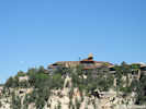
El Tovar Hotel at Grand Canyon | Photograph taken May 30, 2008.
Article records that use this photograph:
images/IMG_0713sm.jpg
| 
Grand Canyon Railroad. | Photograph taken May 30, 2008.
Article records that use this photograph:
images/IMG_0709sm.jpg
| 
Locked Gate | Photograph taken May 30, 2008.
Article records that use this photograph:
images/IMG_0708sm.jpg
| 
The Rowe Well entrance to Grand Canyon National Park | Photograph taken May 30, 2008.
Location records that use this photograph:
Article records that use this photograph:
images/IMG_0707sm.jpg
| Greenlee County
| 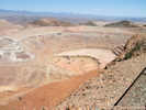
Open pit at Morenci Copper Mine | Photograph taken June 1, 2008.
Article records that use this photograph:
images/IMG_0743sm.jpg
| 
Plaque for the Clifton-Springerville Highway. | Photograph taken June 1, 2008.
Article records that use this photograph:
images/IMG_0754sm.jpg
| 
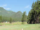
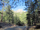
Hannagan Meadow | Photograph taken June 1, 2008.
Location records that use this photograph:
Article records that use this photograph:
images/IMG_0752sm.jpg
| 
Morenci Copper mine from the south. | Photograph taken June 1, 2008.
Article records that use this photograph:
images/IMG00735sm.jpg
| 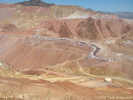
Open pit at Morenci Copper Mine | Photograph taken June 1, 2008.
Article records that use this photograph:
images/IMG_0745sm.jpg
| 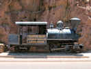
Small tank locomotive on display in Clifton | Photograph taken June 1, 2008.
Location records that use this photograph:
Article records that use this photograph:
images/IMG_0737sm.jpg
| 
Copper mill along US Highway 191 | Photograph taken June 1, 2008.
Article records that use this photograph:
images/IMG00742sm.jpg
| 
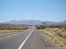
US Highway 191 between Clifton and Morenci | Photograph taken June 1, 2008.
Article records that use this photograph:
images/IMG00741sm.jpg
| 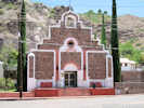
Catholic church in Clifton | Photograph taken June 1, 2008.
Location records that use this photograph:
Article records that use this photograph:
images/IMG_0740sm.jpg
| 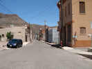
Main street in Clifton. | Photograph taken June 1, 2008.
Location records that use this photograph:
Article records that use this photograph:
images/IMG_0738sm.jpg
| 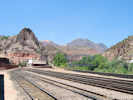
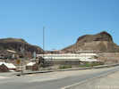
Railyard in Clifton | Photograph taken June 1, 2008.
Location records that use this photograph:
Article records that use this photograph:
images/IMG_0736sm.jpg
| 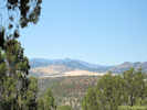
Four Bar Mesa | Photograph taken June 1, 2008.
Location records that use this photograph:
Article records that use this photograph:
images/IMG_0747sm.jpg
| House Rock Valley
| 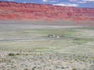
House Rock and ranch. | Photographed 19 April 2017.
Location records that use this photograph:
Article records that use this photograph:
images/IMGQ3819sm.jpg
| 
Interpretive panel at Buffalo Ranch Road. | Photographed 19 April 2017.
Location records that use this photograph:
Article records that use this photograph:
images/IMGQ3825sm.jpg
| 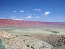
Vermilion Cliffs and House Rock Valley. | Photographed 19 April 2017 with my Samsung Galaxy S5 phone.
Location records that use this photograph:
Article records that use this photograph:
images/IMGQ3818sm.jpg
| Kanab Plateau
| 
View of Shinarump Cliffs from US Highway 89A | Photographed 19 April 2017. This location is near Crowbar Point, and above Johnson Run.
Article records that use this photograph:
images/IMGQ3814sm.jpg
| 
View of Shinarump Cliffs and Muggins Flat from US Highway 89A | Photographed 19 April 2017. This location is near Crowbar Point, and above Johnson Run.
Article records that use this photograph:
images/IMGQ3815sm.jpg
| La Paz County
| 
Stop 2-5. Quarry Wash | Photograph taken April 20, 2008.
Article records that use this photograph:
images/IMG10539sm.jpg
| 
Stop 2-4. Barnacles. | Photograph taken April 20, 2008.
Article records that use this photograph:
images/IMG10536sm.jpg
| 
Trigo Mountains behind the Quarry Wash fossil locality. | Photograph taken April 20, 2008.
Location records that use this photograph:
Article records that use this photograph:
images/IMG10540sm.jpg
| Marble Canyon
| 
Marble Canyon and Vermilion Cliffs. | Photographed 19 April 2017.
Article records that use this photograph:
images/IMGQ3835sm.jpg
| Mohave County
| 
Joshua Tree Parkway | Photographed 18 October 2024.
Article records that use this photograph:
images/20241018_171736sm.jpg
| 
Wikieup Drive-through. | Photographed 18 October 2024.
Location records that use this photograph:
Article records that use this photograph:
images/20241018_163647sm.jpg
| 
Kingman from Hualapai Mountain Road. | Photograph taken May 30, 2008.
Location records that use this photograph:
Article records that use this photograph:
images/IMG_0700sm.jpg
| 
Downtown Peach Springs | Photograph taken May 30, 2008.
Location records that use this photograph:
Article records that use this photograph:
images/IMG_0706sm.jpg
| 
Buck and Doe Road from US Highway 66 | Photograph taken May 30, 2008.
Article records that use this photograph:
images/IMG_0704sm.jpg
| 
Hualapai Mountain from Old US Highway 66 | Photograph taken May 30, 2008.
Location records that use this photograph:
Article records that use this photograph:
images/IMG_0701sm.jpg
| 
Hualapai Peak in Hualapai Mountain Park. | Photograph taken May 30, 2008.
Location records that use this photograph:
Article records that use this photograph:
images/IMG_0699sm.jpg
| 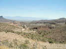
View east from Sitgreaves Pass | Photograph taken May 29, 2008.
Location records that use this photograph:
Article records that use this photograph:
images/IMG_0690sm.jpg
| 
Old US Highway 66 | Photograph taken May 29, 2008.
Article records that use this photograph:
images/IMG_0689sm.jpg
| 
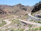
Goldroad Mine | Photograph taken May 29, 2008.
Location records that use this photograph:
Article records that use this photograph:
images/IMG_0688sm.jpg
| 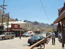
Main street of Oatman, Arizona. | Photograph taken May 29, 2008.
Location records that use this photograph:
Article records that use this photograph: images/IMG_0687sm.jpg
| 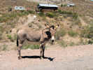
Burro near Oatman, Arizona | Photograph taken May 29, 2008.
Article records that use this photograph:
images/IMG_0686sm.jpg
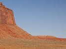
| 
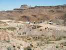
Boundary Cone along Old US Highway 66 | Photograph taken May 29, 2008.
Location records that use this photograph:
Article records that use this photograph:
images/IMG_0677sm.jpg
| 
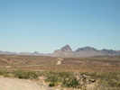
View of Mohave Valley to the southwest | Photograph taken May 29, 2008.
Article records that use this photograph:
images/IMG_0676sm.jpg
| Monument Valley
| 
The View Hotel at Monument Valley. | Photographed 20 April 2017.
Location records that use this photograph:
Article records that use this photograph:
images/IMGQ3843sm.jpg
| 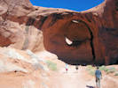
Egg Arch in Monument Valley | Photographed 20 April 2017.
Location records that use this photograph:
Article records that use this photograph:
images/IMGQ3853sm.jpg
| 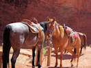
“Diablo,” the Navajo horse. | Photographed 20 April 2017. Note that he is not tied up.
Location records that use this photograph:
Article records that use this photograph:
images/IMGQ3857sm.jpg
| 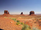
East and West Mitten, and Merrick Butte; the view from our hotel room. | Photographed 20 April 2017.
Location records that use this photograph:
Article records that use this photograph:
images/IMGQ3860sm.jpg
| 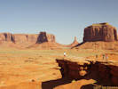
John Ford Point. | Photographed 20 April 2017.
Location records that use this photograph:
Article records that use this photograph:
images/IMGQ3842sm.jpg
| Navajo Bridge
| 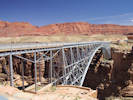
The old bridge (now pedestrian access only) at Navajo Bridge. | Photographed 19 April 2017.
Location records that use this photograph:
Article records that use this photograph:
images/IMGQ3830sm.jpg
| 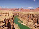
Colorado River upstream of the Navajo Bridge. | Photographed 19 April 2017.
Location records that use this photograph:
Article records that use this photograph:
images/IMGQ3831sm.jpg
| 
Male of condor pair incubates egg while mate is out hunting. | Photographed 19 April 2017.
Location records that use this photograph:
Article records that use this photograph:
images/IMGQ3834sm.jpg
| | ||||||||||||||||||||||