
Eastern Mojave Vegetation
By Tom Schweich
|
Eastern Mojave Vegetation | Images -- Species |
|
By Tom Schweich |
|

Unclassified Geography - Idaho Geography - Park County, CO Geography - Summit County, CO Geography - Arizona Geography - British Columbia Geography - California Geography - California's Colorado Desert Alaska Geography - Mono Lake Basin, California Geography - Mono County, California Geography - San Luis Obispo County, California Geography - Marin County, California Geography - Santa Clara County Alameda Garden Geography - Central Mojave Geography - New Mexico Geography - Eastern Mojave Geography - Northern Mojave Geography - Colorado Geography - Alamosa County, CO Geography - Boulder County, CO Geography - Clear Creek County, CO Geography - Chaffee County, CO Geography - Douglas County, CO Geography - Gilpin County, CO Geography - Golden, Colorado Geography - Weld County, CO Geography - Hinsdale County, CO Geography - Jefferson County, CO Geography - North Table Mountain, Jefferson Cty, CO Geography - Lake County, CO Geography - Larimer County, CO Geography - Nevada Geography - Oregon Geography - South Dakota Geography - Utah Geography - Virginia Geography - Washington Geography - Wyoming Spain - Andalucia Spain - Castilla y Leon Spain - Castilla-La Mancha Spain - Extremadura Spain - Galicia Spain - Madrid Portugal Geology Economic Geology Climatology Botany Salvia dorrii Frasera albomarginata Species Species - Polygonaceae Species - Brassicaceae Species - Brassicaceae, Physaria vitulifera Species - Rosaceae Species - Fabaceae Species - Onagraceae Species - Polemoniaceae Species - Boraginaceae Species - Plantaginaceae Species - Asteraceae Species - Poaceae Zoology Ecology Archeology Customer Satisfaction General Arizona California Kansas Missouri Nebraska New York Christmas 2002 Family Photos Family Documents Family Photos 2003 Art of Lydia Schweich Portraits Railroad Geography - Germany |
Images are organized by the topics listed at left. Click on a topic name to see images with that topic. Would you like to use these photographs in your school term paper or report? License is hereby granted for non-commercial use of the images contained herein provided that the images are reproduced with the copyright notice intact. This means that we give you our permission to use the photographs and information you find here in your school term papers and reports. You may resize the photograph to fit your needs, but you may not remove the copyright. Your term paper should note that the photographs are reproduced with permission and it should have a reference to this web site, such as: "Photograph �1999 Tom Schweich. Used by permission, http://www.schweich.com" If you have a comment or a question about a photograph you may write to me at tomas@schweich.com I will answer you as soon as I can. I sometimes post interesting questions in my FAQ, but I will not disclose your full name or address.
| 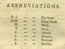
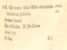
Abbreviations used by Aiton (1789) | Accessed 16 June 2020, URL: https://www.biodiversitylibrary.org/page/3650125#page/29/
Article records that use this photograph:
images/Aiton1789_Abbreviations.jpg
| 
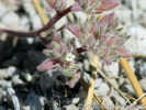
Finished with 2023 collections. | Photographed 10 February 2024.
images/20240210_124757smer.jpg
| 
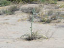
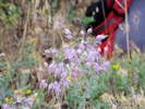
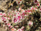
Flower seen near Big Sand Flat. | Photograph taken 25-Jun-07.
Article records that use this photograph:
images/IMGP2695sm.jpg
| 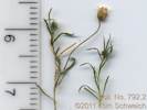
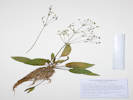
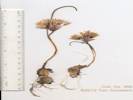
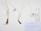
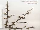
Coll. No. 792.2 | Scanned 29 Dec 2011. This material was found within the materials of collection 792, Mimulus primuloides.
Article records that use this photograph:
images/TAS007922Oview.jpg
| Agavaceae Agave desertii
| 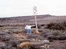
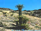
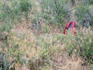
Jim Lons holds up a stalk fo Agave desertii on top of Wild Horse Mesa. | Photographed in April 1982, scanned from a slide in 2023.
Location records that use this photograph:
Article records that use this photograph:
images/1982-04-2-16-img292sm.jpg
| 
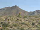
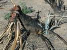
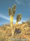
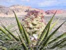
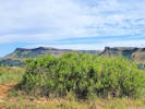
Agave desertii on the rim of Wild Horse Mesa. | Northwestern rim of Wild Horse Mesa.
images/agades.jpg
| 
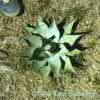
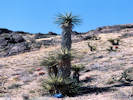
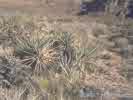
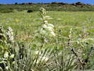
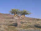
Century Plant (Agave desertii), western edge of Wild Horse Mesa. | This is about as far north as Agave desertii is found. There is a small colony here growing out of crevices in the rocks right on the edge of the mesa. In the right foreground is Buckhorn Cholla (Opuntia acanthocarpa). On the left is Blue Yucca (Yucca baccata).
Article records that use this photograph:
images/wilhoraga.jpg
| Agavaceae Agave utahensis
| 
Utah Agave (Agave utahensis) near Clark Mountain | Photograph taken 6-Jun-06.
Article records that use this photograph:
images/IMG_0548sm.jpg
| Agavaceae Hesperocallis undulata
| 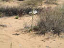
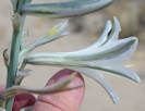
Desert Lily beside Kelbaker Road | Photograph taken April 22, 2008.
Article records that use this photograph:
images/IMG10617sm.jpg
| 
Hesperocallis undulata “Desert Ajo Lily” | Photographed 17 April 2017.
Article records that use this photograph:
images/IMGQ3779sm.jpg
| 
Hesperocallis undulata “Desert Ajo Lily” | Photographed 17 April 2017.
Article records that use this photograph:
images/IMGQ3781sm.jpg
| Agavaceae Nolina sp.
| 
Nolina sp. along Excelsior Mine Road in the Kingston Range. |
Article records that use this photograph:
images/2907-50.jpg
| Agavaceae Yucca baccata
| 
Very tall Yucca baccata in the woods Mountains. | Photographed in April 1985, scanned from a slide in 2023.
Location records that use this photograph:
Article records that use this photograph:
images/1985-04-5-31-img286sm.jpg
| 
Blue Yucca (Yucca baccata) in lower Wild Horse Canyon. |
Article records that use this photograph:
images/yucbac.jpg
| 
Yucca baccata resprouting from the roots. | Photograph taken October 15, 2005.
Article records that use this photograph:
images/IMGP1927sm.jpg
| Agavaceae Yucca brevifolia
| 
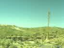
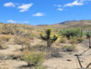
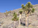
Joshua tree (Yucca brevifolia Engelm.) along Wild Horse Canyon Road. | Photographed in April 1995, scanned from a slide in 2023. Columbia Mountain in the right distance.
Article records that use this photograph:
images/1995-04-img283sm.jpg
| 
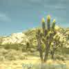
Joshua tree along Old Highway 91. | Photographed 1 April 2025. I had to stop here to pee.
Article records that use this photograph:
images/20250401_121314sm.jpg
| 
Burned Joshua tree in Cedar Canyon | Photograph taken October 16, 2005.
Article records that use this photograph:
images/IMGP2038sm.jpg
| 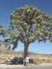
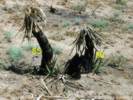
Very large Joshua Tree (Yucca brevifolia) in Joshua Tree National Monument. | A very special person with a large specimen of Joshua Tree (Yucca brevifolia) in Joshua Tree National Monument.
Article records that use this photograph:
images/eileenjosh.jpg
| 
Yucca brevifolia |
Article records that use this photograph:
images/yucbre.jpg
| 
Yucca brevifolia resprouting 1 year after the Hackberry Complex fire. | Photograph taken 7-Jun-06.
Article records that use this photograph:
images/IMGP2398sm.jpg
| 
Joshua trees in Joshua Flats, Inyo County, California. | Photograph taken October 6, 2000.
Location records that use this photograph:
Article records that use this photograph:
images/0091_3182_0174_40.jpg
| 
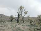
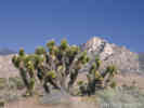
Joshua trees(Yucca brevifolia) in bloom near Caruthers Canyon |
Article records that use this photograph:
images/yucbre_carcyn.jpg
| 
Joshua trees along CA Highway 178 near Onyx |
Article records that use this photograph:
images/1339_3153_1142_50sm.jpg
| 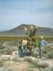
Joshua tree (Yucca brevifolia) in bloom along Kelbaker Road. | Matt, Kate and Roy with Joshua tree (Yucca brevifolia) in bloom along Kelbaker Road. A cinder cone in the Cima Volcanic Field is in the background.
Article records that use this photograph:
images/kelbakyuc.jpg
| Agavaceae Yucca glauca
| 
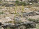
Yucca glauca “Soapweed Yucca” on Dakota Ridge. | Photographed 14 June 2019.
Location records that use this photograph:
Article records that use this photograph:
images/20190614_111320sm.jpg
| Agavaceae Yucca schidigera
| 
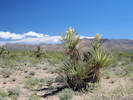
“Mohave Yucca” — Yucca schidigera K. E. Ortiges in bloom at the High Point Overlook. | Photographed 1 April 2025.
Location records that use this photograph:
Article records that use this photograph:
images/20250401_154333sm.jpg
| 
Yucca schidigera | Some unusually tall specimens in lower Wild Horse Canyon.
images/1621-22.jpg
| 
Yucca schidigera | Photograph taken near Hole-in-the-Wall.
images/1621-21.jpg
| 
Yucca schidigera resprouting one year after Hackberry Complex Fire | Photograph taken 8-Jun-06.
Article records that use this photograph:
images/IMGP2451sm.jpg
| 
Mohave Yucca (Yucca schidigera) in lower Wild Horse Canyon. |
Article records that use this photograph:
images/3182-44.jpg
| 
Coll. No. 1575, Yucca schidigera | Photographed 18 April 2017.
Article records that use this photograph:
images/IMGQ3810sm.jpg
| Aizoaceae Sesuvium verrucosum
| 
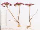
Reynolds Coll. No. 1053, Sesuvium verrucosum | Scanned 31 December 2013.
Location records that use this photograph:
Article records that use this photograph:
images/RER001053Oview.jpg
| Alismataceae Alisma trivale
| 
Coll. No. 1727, Alisma trivale | Photographed 4 January 2018.
Article records that use this photograph:
images/IMGQ4523sm.jpg
| Alliaceae Allium
| 
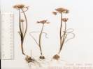
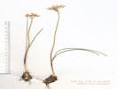
Coll. No. 296, Allium acuminatum | Scanned 14 August 2012.
Article records that use this photograph:
images/TAS002960Oview.jpg
| 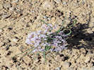
Allium seen at The Squeeze Rest Stop. | Photographed 12 April 2017.
Location records that use this photograph:
Article records that use this photograph:
images/IMGQ3690sm.jpg
| Alliaceae Allium � proliferum
| 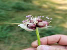
Head of Coll. No. 2415, Allium � proliferum | Photographed 19 August 2020.
Article records that use this photograph:
images/20200819_122344sm.jpg
| Alliaceae Allium atrorubens cristatum
| 
Scan of Coll. No. 388, Allium atrorubens var. cristatum | Scanned 9 August 2012. Collection No. 388, 9 August 2012, characters observed while keying: Geophyte, bulblets present, Stem 5 cm., Leaves 1 per stem, Pedicels 11 mm. (> perianth), Perianth parts 9-10 mm., � equal, entire, pink, darker veins, flat margins, Stamens included, Stigma lobes � 0.
Article records that use this photograph:
images/TAS003880Oview.jpg
| Alliaceae Allium bisceptrum
| 
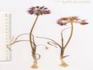
Coll. No. 295, Allium bisceptrum | Scanned 14 August 2012. I'm not really comfortable with this determination. There were a few characters observed that clearly led one astray in the keys. I used the FNANM key.
Article records that use this photograph:
images/TAS002950_Oview_150.jpg
| 
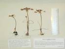
Coll. No. 856, Allium bisceptrum | Scanned 20 February 2013.
Location records that use this photograph:
Article records that use this photograph:
images/TAS008560Oviewsm.jpg
| Alliaceae Allium campanulatum
| 
Coll. No. 934, Allium campanulatum | Photographed 3 March 2015. Coll. No. 934, 20 May 2013, characters observed while “keying:” Perennial, 15 cm., from bulb; Bulb, 13 mm., ovoid; Leaves, 1–3, withered at flowering; Flowers 18; Perianth, 7-8 mm., keeled, tip margins in-rolled, no special coloration at adaxial base, papery in fruit. Between A. bisceptrum and A. campanulatum, I went with the latter on the strength of leaves withered in flower, perianth keeled and tip margins in-rolled, and ignored perianth papery in fruit, and absence of a basal adaxial purple crescent.
Location records that use this photograph:
Article records that use this photograph:
images/IMG40891sm.jpg
| Alliaceae Allium cernuum
| 
Coll. No. 3189, Allium cernuum. | Photographed 28 January 2024.
Article records that use this photograph:
images/IMGQ6081sm.jpg
| 
Coll. No. 1240, Allium cernuum | Photographed 24 July 2015.
Location records that use this photograph:
Article records that use this photograph:
images/IMGQ1309sm.jpg
| 
Habitat of Coll. No. 1240, Allium cernuum | Photographed 24 July 2015.
Location records that use this photograph:
Article records that use this photograph:
images/IMGQ1306sm.jpg
| Alliaceae allium geyeri
| 
Coll. No. 1417, Allium geyeri | Scanned 6 December 2016.
Article records that use this photograph:
images/TAS014170Oview.jpg
| Alliaceae Allium geyeri
| 
Habitat of Coll. No. 1417, Allium, perhaps A. geyeri | Photographed 10 June 2016. Determination tentative.
Article records that use this photograph:
images/IMGQ2716sm.jpg
| Alliaceae Allium sp.
| 
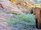
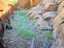
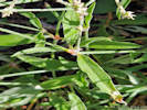
Horticultural Allium escaped to Kinney Run. | Photographed 31 July 2020.
Article records that use this photograph:
images/20200731_120805sm.jpg
| Alliaceae Allium textile
| 
Coll. No. 2933, Allium textile | Photographed 31 October 2023.
Article records that use this photograph:
images/IMGQ5931sm.jpg
| 
Coll. No. 2302, Allium textile | Photographed 26 May 2020.
Article records that use this photograph:
images/20200526_104436sm.jpg
| 
Habitat of Coll. No. 1134, Alliaceae Allium textile | Photographed 9 June 2015.
Article records that use this photograph:
images/IMGQ0793sm.jpg
| 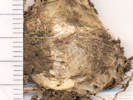
Bulb coat of Coll. No. 1134, Allium textile | Scanned 10 October 2015.
Article records that use this photograph:
images/TAS011340Bulb.jpg
| 
Coll. No. 1134, Allium textile | Scanned 10 October 2015.
Article records that use this photograph:
images/TAS011340Oview.jpg
| Amaranthaceae Amaranthus albus
| 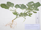
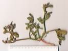
Coll. No. 3045, Amaranthus albus. | Photographed 23 December 2023.
Article records that use this photograph:
images/IMGQ6003sm.jpg
| Amaranthaceae Amaranthus torreyi
| 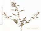
Coll. No. 141, Amaranthus torreyi | Scanned 22 May 2015. Coll. No. 141, 3 Oct 1997, characters observed: Annual, tap-rooted, to 30 cm., monoecious; Nodes, without spines; Leaves, alternate, petiole 15 mm., blade 26 mm. × 9 mm. wide, lanceolate, base wedge-spaped, tip small mucronate; Inflorescence axillary; Flowers, pistillate, perianth parts #5, 2 mm., ±equal, oblong; Ovary, 1 mm.; Styles, #3, 0.8 mm.; Seed, 1.6 mm., dark red-brown.
Article records that use this photograph:
images/TAS001410Oview.jpg
| Amaranthaceae Froelichia gracilis
| 
Coll No. 3206, Froelichia gracilis. | Photographed 30 August 2023.
Article records that use this photograph:
images/20230830_094230sm.jpg
| 
Coll No. 3206, Froelichia gracilis. | Photographed 30 August 2023.
Article records that use this photograph:
images/20230830_094140sm.jpg
| 
Coll No. 3206, Froelichia gracilis. | Photographed 29 August 2023.
Article records that use this photograph:
images/20230829_100502sm.jpg
| Amaranthaceae Kochia scoparia
| 
Inflorescence of Coll. No. 2577, Kochia scoparia | Scanned 19 Sep 2021.
Coll. No. 2755, 16 Sep 2021, characters observed: Annual, to 1 m., terrestrial, herbaceous, sap clear, not parasitic, not fern-like, without stinging hairs; Stem, with ascending multi-cellular hairs; Leaves, alternate, green, linear, 60 mm. × 6 mm. wide, veins #3 + reticulate, surface, adaxial pubescent, abaxial long silky appressed, margin ciliate, tip acute, no bristle; Inflorescence, bracteate, though some flowers borne singly on the rachis (i.e., not bracted), Bracts, 4 mm. × 1 mm. wide, lanceolate, green, mid-vein green, somewhat obscure, margin long ciliate; Rachis, densely long hairy; Perianth, sepaloid, single whorl, glabrous, not hooked, horizontally winged in fruit; Sepals, #5, fleshy; Stamens, #4; Ovary, enclosing seeds, carpels united; Stigmas, #2; Fruit, not a silicle.
Article records that use this photograph:
images/TAS027550Infl.jpg
| 
Habit of Coll. No. 2577, Kochia scoparia | Photographed 19 Sep 2021.
Coll. No. 2755, 16 Sep 2021, characters observed: Annual, to 1 m., terrestrial, herbaceous, sap clear, not parasitic, not fern-like, without stinging hairs; Stem, with ascending multi-cellular hairs; Leaves, alternate, green, linear, 60 mm. × 6 mm. wide, veins #3 + reticulate, surface, adaxial pubescent, abaxial long silky appressed, margin ciliate, tip acute, no bristle; Inflorescence, bracteate, though some flowers borne singly on the rachis (i.e., not bracted), Bracts, 4 mm. × 1 mm. wide, lanceolate, green, mid-vein green, somewhat obscure, margin long ciliate; Rachis, densely long hairy; Perianth, sepaloid, single whorl, glabrous, not hooked, horizontally winged in fruit; Sepals, #5, fleshy; Stamens, #4; Ovary, enclosing seeds, carpels united; Stigmas, #2; Fruit, not a silicle.
Article records that use this photograph:
images/20210916_130104sm.jpg
| 
Coll. No. 2577, Kochia scoparia | Photographed 19 Sep 2021.
Coll. No. 2755, 16 Sep 2021, characters observed: Annual, to 1 m., terrestrial, herbaceous, sap clear, not parasitic, not fern-like, without stinging hairs; Stem, with ascending multi-cellular hairs; Leaves, alternate, green, linear, 60 mm. × 6 mm. wide, veins #3 + reticulate, surface, adaxial pubescent, abaxial long silky appressed, margin ciliate, tip acute, no bristle; Inflorescence, bracteate, though some flowers borne singly on the rachis (i.e., not bracted), Bracts, 4 mm. × 1 mm. wide, lanceolate, green, mid-vein green, somewhat obscure, margin long ciliate; Rachis, densely long hairy; Perianth, sepaloid, single whorl, glabrous, not hooked, horizontally winged in fruit; Sepals, #5, fleshy; Stamens, #4; Ovary, enclosing seeds, carpels united; Stigmas, #2; Fruit, not a silicle.
Article records that use this photograph:
images/20210916_130803sm.jpg
| Amaranthaceae Salsola tragus
| 
Red-flowered variant of tumbleweed (Salsola tragus L.) | Photographed 26 September 2022 at the Oregon Trail Overlook of Hagerman Fossil Beds National Monument, Gooding County, Idaho.
Article records that use this photograph:
images/IMGQ5697sm.jpg
| 
Flowers of red-flowered variant of tumbleweed (Salsola tragus L.) | Photographed 26 September 2022 at the Oregon Trail Overlook of Hagerman Fossil Beds National Monument, Gooding County, Idaho.
Article records that use this photograph:
images/IMGQ5699sm.jpg
| Anacardiaceae Rhus aromatica
| 
Aiton (1789) description of Rhus aromatica | Accessed 15 June 2020, URL: https://www.biodiversitylibrary.org/page/3650125#page/397/
Article records that use this photograph:
images/154Rhuaro_Aiton1789.jpg
| Anacardiaceae Rhus glabra
| 
Coll. No. 2556, Rhus glabra. | Photographed 26 November 2021.
Article records that use this photograph:
images/IMGQ5501sm.jpg
| 
Last year's fruit on Rhus glabra | Photographed 6 May 2021.
Location records that use this photograph:
Article records that use this photograph:
images/20210506_114911sm.jpg
| Anacardiaceae Rhus microphylla
| 
Coll. No. 733, Rhus microphylla | Scanned 1 Jan 2012.
Article records that use this photograph:
images/TAS007330Oview.jpg
| Anacardiaceae Rhus trilobata
| 
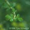
Rhus trilobata at the southern end of the Survey Field. | Phototographed 20 June 2020.
Article records that use this photograph:
images/20200620_091452sm.jpg
| 
Nuttall's description of Rhus trilobata in Torrey & Gray (1838). | Accessed 16 June 2020, URL: https://www.biodiversitylibrary.org/page/5290687#page/241/
Article records that use this photograph:
images/TorreyJG1838_154Rhutri.jpg
| 
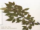
Rhus trilobata at Ranson/Edwards. | Phototographed 23 June 2020.
Article records that use this photograph:
images/20200623_112158sm.jpg
| 
Gray's description of Rhus aromatica var. trilobata in Watson (1871). | Scanned 16 June 2020. Book in my library.
Location records that use this photograph:
Article records that use this photograph:
images/154Rhuarotri_Watson1871.jpg
| 
Coll. No. 2139, Rhus trilobata. | Scanned 4 December 2019.
Article records that use this photograph:
images/TAS021390Oview.jpg
| 
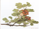
Rhus trilobata | I think this photo was taken in Mojave National Preserve.
images/rhutri.jpg
| Anacardiaceae Rhus virens choriophylla
| 
Coll. No. 734, Rhus virens var. choriophylla | Scanned 1 Jan 2012.
Article records that use this photograph:
images/TAS007340Oview.jpg
| Anacardiaceae Toxicodendron rydbergii
| 
Western Poison Ivy on the backbone of Dakota Ridge. | Photographed 17 September 2020.
Article records that use this photograph:
images/20200917_100056sm.jpg
| Anacardiaceae Toxicodenfron rydbergii
| 
Poison Ivy in the Survey Field. | Photographed 28 May 2018.
Location records that use this photograph:
Article records that use this photograph:
images/IMG50249sm.jpg
| Anthericeae Leucocrinum montanum
| 
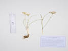
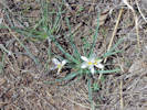
Habitat of Coll. No. 2254, Leucocrinum montanum | Photographed 4 May 2020.
Article records that use this photograph:
images/20200504_101005sm.jpg
| 
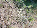
Leucocrinum montanum in Long Valley. | Photograph taken 21 June 2011.
Article records that use this photograph:
images/IMG_1988sm.jpg
| 
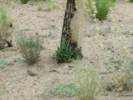
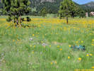
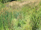
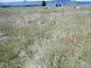
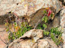
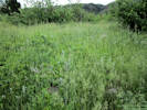
Habitat of Leucocrinum montanum and Townsendia hookeri in the Survey Field. | Photographed 9 April 2016. Very little ground cover at this early spring time.
Article records that use this photograph:
images/IMGQ2305sm.jpg
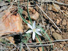
| 
Leucocrinum montanum on south-facing slope. | Photographed 27 March 2017.
Location records that use this photograph:
Article records that use this photograph:
images/IMGQ3626sm.jpg
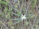
| 
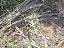
Leucocrinum montanum on an old alluvial ridge in the Survey Field. | Photographed 9 April 2016.
Article records that use this photograph:
images/IMGQ2309sm.jpg
| 
Leucocrinum montanum on an old alluvial ridge in the Survey Field. | Photographed 9 April 2016.
Article records that use this photograph:
images/IMGQ2312sm.jpg
| 
Star Lily (Leucocrinum montanum) as seen on Tin Cup Ridge. | Photographed 14 May 2015.
Location records that use this photograph:
Article records that use this photograph:
images/IMGQ0511sm.jpg
| | |||||||||||||||||||||||||||||||||||||||||||||||||||||||||||||||||