
Eastern Mojave Vegetation
By Tom Schweich
|
Eastern Mojave Vegetation | Images -- Species - Polygonaceae |
|
By Tom Schweich |
|

Unclassified Geography - Idaho Geography - Park County, CO Geography - Summit County, CO Geography - Arizona Geography - British Columbia Geography - California Geography - California's Colorado Desert Alaska Geography - Mono Lake Basin, California Geography - Mono County, California Geography - San Luis Obispo County, California Geography - Marin County, California Geography - Santa Clara County Alameda Garden Geography - Central Mojave Geography - New Mexico Geography - Eastern Mojave Geography - Northern Mojave Geography - Colorado Geography - Alamosa County, CO Geography - Boulder County, CO Geography - Clear Creek County, CO Geography - Chaffee County, CO Geography - Douglas County, CO Geography - Gilpin County, CO Geography - Golden, Colorado Geography - Weld County, CO Geography - Hinsdale County, CO Geography - Jefferson County, CO Geography - North Table Mountain, Jefferson Cty, CO Geography - Lake County, CO Geography - Larimer County, CO Geography - Nevada Geography - Oregon Geography - South Dakota Geography - Utah Geography - Virginia Geography - Washington Geography - Wyoming Spain - Andalucia Spain - Castilla y Leon Spain - Castilla-La Mancha Spain - Extremadura Spain - Galicia Spain - Madrid Portugal Geology Economic Geology Climatology Botany Salvia dorrii Frasera albomarginata Species Species - Polygonaceae Species - Brassicaceae Species - Brassicaceae, Physaria vitulifera Species - Rosaceae Species - Fabaceae Species - Onagraceae Species - Polemoniaceae Species - Boraginaceae Species - Plantaginaceae Species - Asteraceae Species - Poaceae Zoology Ecology Archeology Customer Satisfaction General Arizona California Kansas Missouri Nebraska New York Christmas 2002 Family Photos Family Documents Family Photos 2003 Art of Lydia Schweich Portraits Railroad Geography - Germany |
Images are organized by the topics listed at left. Click on a topic name to see images with that topic. Would you like to use these photographs in your school term paper or report? License is hereby granted for non-commercial use of the images contained herein provided that the images are reproduced with the copyright notice intact. This means that we give you our permission to use the photographs and information you find here in your school term papers and reports. You may resize the photograph to fit your needs, but you may not remove the copyright. Your term paper should note that the photographs are reproduced with permission and it should have a reference to this web site, such as: "Photograph ©1999 Tom Schweich. Used by permission, http://www.schweich.com" If you have a comment or a question about a photograph you may write to me at tomas@schweich.com I will answer you as soon as I can. I sometimes post interesting questions in my FAQ, but I will not disclose your full name or address.
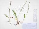
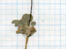
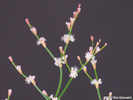
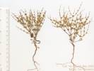
| Bistorta bistortoides
| 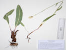
Coll. No. 3122, Bistorta bistortoides. | Photographed 13 January 2024.
Article records that use this photograph:
images/IMGQ6060sm.jpg
| 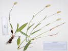
Coll. No. 2583, Bistorta bistortoides | Photographed 9 December 2021.
Article records that use this photograph:
images/IMGQ5519sm.jpg
| 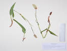
Coll. No. 1480, Bistorta bistortoides | Photographed 26 December 2016.
Article records that use this photograph:
images/IMGQ3496sm.jpg
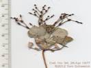
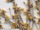
| Bistorta vivipara
| 
Coll. No. 3130, Bistorta vivipara. | Photographed 20 July 2023.
Article records that use this photograph:
images/20230719_113401sm.jpg
| 
Coll. No. 2878.1, Bistorta vivipara. | Photographed 1 December 2022.
Article records that use this photograph:
images/IMGQ5753sm.jpg
| 
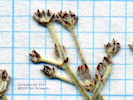
Coll. No. 3348.2, Bistorta vivipara. | Scanned 27 December 2024.
Article records that use this photograph:
images/TAS033482Infl.jpg
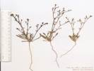
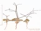
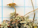
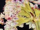
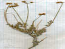
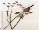
| Chorizanthe
| 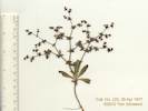
Coll. No. 123 | Scanned 16 October 2012.
Article records that use this photograph:
images/TAS001230Oview.jpg
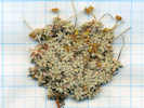
| 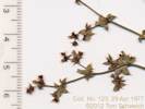
Coll. No. 123 | Scanned 16 October 2012.
Article records that use this photograph:
images/TAS00123Det.jpg
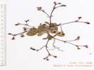
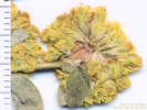
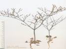
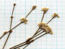
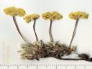
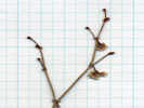
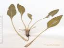
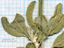
| Chorizanthe brevicornu brevicornu
| 
Coll. No. 340.1, Chorizanthe brevicornu var. brevicornu | Scanned 17 October 2012.
Article records that use this photograph:
images/TAS003401Oview.jpg
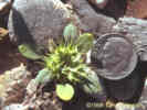
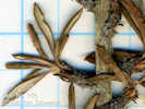
| Chorizanthe brevicornu spathulata
| 
Overview of Coll. No. 396, Chorizanthe brevicornu var. spathulatum | Scanned 15 August 2012. Tentative determination.
Article records that use this photograph:
images/TAS003960Oview.jpg
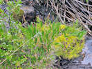
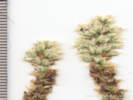
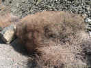
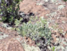
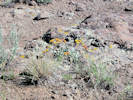
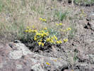
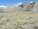
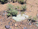
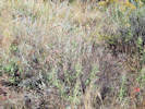
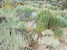
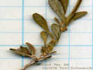
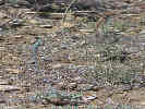
| Chorizanthe rigida
| 
Chorizanthe rigida in the Cima Volcanic Field. |
images/1621-02.jpg
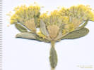
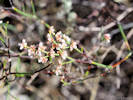
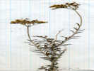
| Dedeckera eurekensis
| 
July Gold (Dekeckera eurekensis) as seen in May. | Photograph taken 13-May-07 in Coldwater Canyon.
Location records that use this photograph:
images/IMG_1554sm.jpg
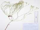
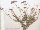
| Eriogonum
| 
Collection Number 469 | Big Sand Flat, Mono County, California. Collected on the ridge just northwest of Big Sand Flat in an area that had burned several years previously. 37.8872°N, 118.898°W. UTM: 11S 4194993N 333197E. Elev. 8000 ft.
Article records that use this photograph:
images/TAS004690oview.jpg
| 
Coll. No. 94, Eriogonum | Scanned 16 October 2012. Collection immature, discarded.
Article records that use this photograph:
images/TAS000940Oview.jpg
| 
Coll. No. 252, Eriogonum | Scanned 23 May 2015. Collection immature, discarded.
Article records that use this photograph:
images/TAS002520Oview.jpg
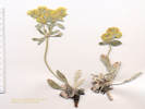
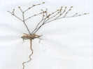
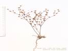
| Eriogonum actuatum
| 
Coll. No. 1232, Eriogonum | Scanned 16 December 2015. Coll. No. 1232, 20 Jul 2015, characters observed: Perennial herb, to 15 cm., caespitose but not mat-forming, scapose; Leaves, basal, petiole 8-10 mm. + blade 40-45 mm. × 12-18 mm. wide, elliptic-oblanceolate, adaxial tomentose but still ±green, abaxial densely white tomentose; Inflorescence, scape, 100 mm., bracts, #8, 2° branching, but not umbellate, 1° branch 35-40 mm., 2° branch (peduncle), ±15 mm.; Involucre, #8-10 per scape, tube 3.5 mm. + lobes 1 mm., rounded, reflexed; Flowers, stipe-like base, 0.8 mm.; Perianth, bright yellow, fading red, 6 mm. (measured from base of stipe), long straight hairy.
Article records that use this photograph:
images/TAS012310Invol.jpg
| Eriogonum alatum
| 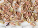
Seed of Eriogonum alatum | Scanned 29 August 2020. Seed collected 28 August 2020 on Eagle Ridge.
Article records that use this photograph:
images/78Eriala_seed_sm.jpg
| 
Voucher of Coll. No. 2390, Eriogonum alatum | Photographed 5 January 2020. This voucher will be distributed to JCOS.
Article records that use this photograph:
images/IMGQ5306sm.jpg
| 
Eriogonum alatum | Photographed 22 July 2016, North Table Mountain Park, Jefferson County, Colorado.
Location records that use this photograph:
Article records that use this photograph:
images/IMGQ3004sm.jpg
| 
Inflorescence and leaves of Coll. No. 1238, Eriogonum alatum | Scanned 19 December 2015.
Article records that use this photograph:
images/TAS012380Oview.jpg
| 
Involucre, flowers and achenes of Coll. No. 1238, Eriogonum alatum | Scanned 19 December 2015.
Article records that use this photograph:
images/TAS012380Achene.jpg
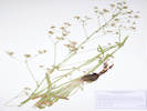
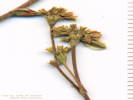
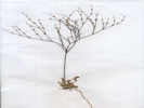
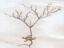
| Eriogonum arcuatum
| 
Eriogonum arcuatum on top of North Table Mountain. | Photographed 22 May 2024.
Location records that use this photograph:
Article records that use this photograph:
images/20240522_113030sm.jpg
| 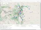
Map of collections determined one of the two taxa of Eriogonum in Colorado | Map generated 21 September 2020.
Article records that use this photograph:
images/SEINet20200921_78Eriogonum.jpg
| 
Eriogonum arcuatum on top of North Table Mountain. | Photographed 22 May 2024.
Location records that use this photograph:
Article records that use this photograph:
images/20240522_113338sm.jpg
| 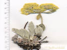
Coll. No. 1401.1, Eriogonum arcuatum | Scanned 15 December 2016. Coll. No. 1401.1, 8 Jun 2015, characters observed: Perennial, caespitose, to 10 cm.; Leaves, basal, elliptic, petiole 10 mm. + blade 30 mm. × 12 mm. wide, adaxial greenish floccose, abaxial tomentose; Flowering stems, without a whorl of bracts mid-stem; Inflorescence, umbellate (simple, not compound); Involucre, sessile (not peduncled), 4.5 mm., hairy, teeth, very short; Flowers, (obscurely) attenuate at base; Perianth, 4.5-6.0 mm., bright yellow, hairy.
Article records that use this photograph:
images/TAS014011Oview.jpg
| 
Coll. No. 1695, Eriogonum arcuatum | Scanned 28 December 2017.
Article records that use this photograph:
images/TAS016950Oview.jpg
| 
Inflorescence of Coll. No. 1695, Eriogonum arcuatum | Scanned 28 December 2017.
Article records that use this photograph:
images/TAS016950Infl.jpg
| 
Coll. No. 1232, Eriogonum | Photographed 20 July 2015. Coll. No. 1232, 20 Jul 2015, characters observed: Perennial herb, to 15 cm., caespitose but not mat-forming, scapose; Leaves, basal, petiole 8-10 mm. + blade 40-45 mm. × 12-18 mm. wide, elliptic-oblanceolate, adaxial tomentose but still ±green, abaxial densely white tomentose; Inflorescence, scape, 100 mm., bracts, #8, 2° branching, but not umbellate, 1° branch 35-40 mm., 2° branch (peduncle), ±15 mm.; Involucre, #8-10 per scape, tube 3.5 mm. + lobes 1 mm., rounded, reflexed; Flowers, stipe-like base, 0.8 mm.; Perianth, bright yellow, fading red, 6 mm. (measured from base of stipe), long straight hairy.
Article records that use this photograph:
images/IMGQ1291sm.jpg
| 
Inflorescence of Coll. No. 1401.1, Eriogonum arcuatum | Scanned 15 December 2016. The thing to see here are sessile involucres. If the involucres were peduncled then we might think this was E. flavum. Coll. No. 1401.1, 8 Jun 2015, characters observed: Perennial, caespitose, to 10 cm.; Leaves, basal, elliptic, petiole 10 mm. + blade 30 mm. × 12 mm. wide, adaxial greenish floccose, abaxial tomentose; Flowering stems, without a whorl of bracts mid-stem; Inflorescence, umbellate (simple, not compound); Involucre, sessile (not peduncled), 4.5 mm., hairy, teeth, very short; Flowers, (obscurely) attenuate at base; Perianth, 4.5-6.0 mm., bright yellow, hairy.
Article records that use this photograph:
images/TAS014011Infl.jpg
| 
Coll. No. 1232, Eriogonum | Scanned 16 December 2015. Coll. No. 1232, 20 Jul 2015, characters observed: Perennial herb, to 15 cm., caespitose but not mat-forming, scapose; Leaves, basal, petiole 8-10 mm. + blade 40-45 mm. × 12-18 mm. wide, elliptic-oblanceolate, adaxial tomentose but still ±green, abaxial densely white tomentose; Inflorescence, scape, 100 mm., bracts, #8, 2° branching, but not umbellate, 1° branch 35-40 mm., 2° branch (peduncle), ±15 mm.; Involucre, #8-10 per scape, tube 3.5 mm. + lobes 1 mm., rounded, reflexed; Flowers, stipe-like base, 0.8 mm.; Perianth, bright yellow, fading red, 6 mm. (measured from base of stipe), long straight hairy.
Article records that use this photograph:
images/TAS012320Oview.jpg
| 
Coll. No. 1232, Eriogonum | Photographed 20 July 2015. Bouteloua gracilis (Blue Grama) in the background. Coll. No. 1232, 20 Jul 2015, characters observed: Perennial herb, to 15 cm., caespitose but not mat-forming, scapose; Leaves, basal, petiole 8-10 mm. + blade 40-45 mm. × 12-18 mm. wide, elliptic-oblanceolate, adaxial tomentose but still ±green, abaxial densely white tomentose; Inflorescence, scape, 100 mm., bracts, #8, 2° branching, but not umbellate, 1° branch 35-40 mm., 2° branch (peduncle), ±15 mm.; Involucre, #8-10 per scape, tube 3.5 mm. + lobes 1 mm., rounded, reflexed; Flowers, stipe-like base, 0.8 mm.; Perianth, bright yellow, fading red, 6 mm. (measured from base of stipe), long straight hairy.
Article records that use this photograph:
images/IMGX1294sm.jpg
| Eriogonum baileyi baileyi
| 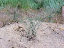
Dirt-pile Habitat of Eriogonum baileyi var. baileyi near Sagehen Meadow | Photograph taken 8 August 2010.
Location records that use this photograph:
Article records that use this photograph:
images/IMGP0765sm.jpg
| 
Flower of Eriogonum baileyi var. baileyi. | Photograph taken 8 August 2010.
Location records that use this photograph:
Article records that use this photograph:
images/IMGP0760sm.jpg
| 
Infloresence of Eriogonum baileyi var. baileyi. | Photograph taken 8 August 2010.
Location records that use this photograph:
Article records that use this photograph:
images/IMGP0759sm.jpg
| 
Coll. No. 696, Eriogonum baileyi var. baileyi | Scanned 13 Nov 2011. Coll. No. 696, 13 Nov 2011, characters observed while keying; Annual; Stem glabrous; Leaves basal; Infloresence elongate; Involucres subtended by bracts, sessile, 2 mm, ribbed; Flowers glabrous, 1.5 mm, white to rose.
Article records that use this photograph:
images/TAS006960Oview.jpg
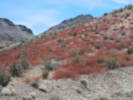
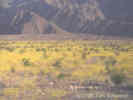
| 
Dense growth of Coll. No. 892 Eriogonum baileyi var. baileyi two years after the Crater Fire. | Photographed 23 August 2012. Coll. No. 892, 23 August 2012, characters observed while keying: Annual, to 30 cm; Stem glabrous; Leaves, basal, ±round, tomentose, but withered at anthesis; Peduncles 0; Involucre, 2 mm, 5-toothed, slightly ribbed, sessile, appressed along branched and at tips of branchlets, glabrous, ciliate at margins; Flowers 1.8-2.0 mm; Petals, oblong, constricted toward middle giving the perianth a bell shape, small patches of color tending toward red rather than yellow, should be minutely glandular but not visible at 50x.
Article records that use this photograph:
images/IMG30631sm.jpg
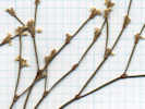
| Eriogonum brachyanthum
| 
Collection No. 509, Eriogonum brachyanthum | Scanned 16 March 2011. Background grid is 10 x 10 to the inch.
Article records that use this photograph:
images/TAS005090oview.jpg
| 
Collection No. 519, Eriogonum brachyanthum | Scanned 19 March 2011. Background grid is 10 x 10 to the inch.
Article records that use this photograph:
images/TAS005190oview.jpg
| 
Collection No. 492.1 | Scanned 3 March 2011. Background grid is 10 x 10 to the inch.
Article records that use this photograph:
images/TAS004921infl.jpg
| 
Collection No. 509, Eriogonum brachyanthum | Scanned 16 March 2011. Background grid is 10 x 10 to the inch.
Article records that use this photograph:
images/TAS005090det.jpg
| 
Collection No. 492.1 | Scanned 3 March 2011. Background grid is 10 x 10 to the inch.
Article records that use this photograph:
images/TAS004911oview.jpg
| Eriogonum caespitosum
| 
Coll No. 486 Eriogonum caespitosum | Photograph taken 26-Jun-07.
Article records that use this photograph:
images/IMG_1812sm.jpg
| 
Coll. No. 486, Eriogonum caespitosum | The grid spacing is 1/4 inch. Coll. No. 486, 27 Nov 2011, characters observed while keying; Perennial matted; Peduncle bractless (TJM2 says "stem bractless" and Taylor says "infloresence bractless"); Tepals uniform in width, reflexed; Perianth base extended slightly to an expanded joint-like abcission zone, yellow, hairy.
Article records that use this photograph:
images/TAS004860det.jpg
| 
Coll. No. 486, Eriogonum caespitosum | The grid spacing is 1/4 inch.
Article records that use this photograph:
images/TAS004860oview.jpg
| 
Coll. No. 967, Eriogonum caespitosum | Scanned on 8 Feb 2014.
Article records that use this photograph:
images/TAS009670Oview.jpg
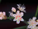
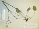
| Eriogonum davidsonii
| 
Coll. No. 140, Eriogonum davidsonii | Scanned 23 May 2015. Coll. No. 140, 22 Sep 1997, characters observed: Annual, tap-rooted, to 18 cm.; Leaves, basal only, petiole 7 mm., blade 13 mm. × 11 mm. wide, round-ovate; Involucre, sessile in axils, 2.5 mm., angled, margins hairy; Flowers, 2 mm., pink, glabrous, outer perianth lobes neither fan-shaped nor hastate.
Article records that use this photograph:
images/TAS001400Oview.jpg
| Eriogonum deflexum nevadense
| 
Collection No. 492.2, Eriogonum deflexum var. nevadense | Scanned 3 March 2011. Background grid is 10 x 10 to the inch.
Article records that use this photograph:
images/TAS004922infl.jpg
| 
Collection No. 492.2, Eriogonum deflexum var. nevadense | Scanned 3 March 2011. Background grid is 10 x 10 to the inch.
Article records that use this photograph:
images/TAS004922oview.jpg
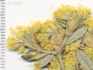
| Eriogonum effusum
| 
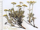
Voucher of Coll. No. 2431.1, Eriogonum effusum | Photographed 7 January 2020. This voucher will be distributed to JCOS.
Article records that use this photograph:
images/IMGQ5310sm.jpg
| 
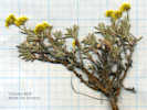
Coll. No. 3192, Eriogonum effusum. | Photographed 29 January 2024.
Article records that use this photograph:
images/IMGQ6084sm.jpg
| 
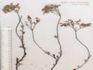
Eriogonum effusum along trail at Red Rocks | Photographed 7 October 2015.
Article records that use this photograph:
images/IMGQ1735sm.jpg
| 
Eriogonum effusum along trail at Red Rocks | Photographed 7 October 2015.
Article records that use this photograph:
images/IMGQ1733sm.jpg
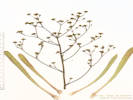
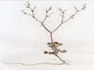
| Eriogonum elatum elatum
| 
Coll. No. 1030, Eriogonum elatum var. elatum | Photographed 11 February 2015. Coll. No. 1030, 24 Jul 2015, characters observed while keying: Perennial erect herb from caudex, to 80 cm.; Stem to 50 cm., not jointed, slightly inflated, glabrous; Leaves, petioles 11-13 cm., ovate-elliptic, 8-9 cm. × 2.5-3.5 cm. wide, short-hairy adaxially, hairy to near-tomentose abaxially; Inflorescence branched, branches glabrous; Involucre, 2-3 per node, 15 mm. wide; Pedicels glabrous; Stipe 0; Flower hairy; Perianth lobes 5, all alike.
Article records that use this photograph:
images/IMGQ0108sm.jpg
| 
Coll. No. 1030, Eriogonum elatum var. elatum | Photographed 10 February 2015. Coll. No. 1030, 24 Jul 2015, characters observed while keying: Perennial erect herb from caudex, to 80 cm.; Stem to 50 cm., not jointed, slightly inflated, glabrous; Leaves, petioles 11-13 cm., ovate-elliptic, 8-9 cm. × 2.5-3.5 cm. wide, short-hairy adaxially, hairy to near-tomentose abaxially; Inflorescence branched, branches glabrous; Involucre, 2-3 per node, 15 mm. wide; Pedicels glabrous; Stipe 0; Flower hairy; Perianth lobes 5, all alike.
Article records that use this photograph:
images/IMG40871sm.jpg
| 
Coll. No. 1030, Eriogonum elatum var. elatum | Photographed 24 July 2013.
Article records that use this photograph:
images/IMG_1622sm.jpg
| 
Coll. No. 1030, Eriogonum elatum var. elatum | Scanned 10 February 2015. Coll. No. 1030, 24 Jul 2015, characters observed while keying: Perennial erect herb from caudex, to 80 cm.; Stem to 50 cm., not jointed, slightly inflated, glabrous; Leaves, petioles 11-13 cm., ovate-elliptic, 8-9 cm. × 2.5-3.5 cm. wide, short-hairy adaxially, hairy to near-tomentose abaxially; Inflorescence branched, branches glabrous; Involucre, 2-3 per node, 15 mm. wide; Pedicels glabrous; Stipe 0; Flower hairy; Perianth lobes 5, all alike.
Article records that use this photograph:
images/TAS010300Base.jpg
| Eriogonum fasciculatum polifolium
| 
Collection No. 86, Eriogonum fasciculatum var. polifolium |
Article records that use this photograph:
images/TAS000860oview.jpg
| 
Collection No. 160, Eriogonum fasciculatum ssp. polifolium |
Article records that use this photograph:
images/TAS001600det.jpg
| 
Collection No. 86, Eriogonum fasciculatum var. polifolium |
Article records that use this photograph:
images/TAS000860infl.jpg
| 
Collection No. 86, Eriogonum fasciculatum var. polifolium |
Article records that use this photograph:
images/TAS000860det.jpg
| 
Collection No. 160, Eriogonum fasciculatum ssp. polifolium |
Article records that use this photograph:
images/TAS001600oview.jpg
| 
Coll. No. 322, Eriogonum fasciculatum var. polifolium | Scanned 21 October 2012.
Article records that use this photograph:
images/TAS003320Oview.jpg
| Eriogonum inflatum
| 
Red stems from last year's Eriogonum inflatum. | Photographed 2 April 2025.
Article records that use this photograph:
images/20250402_090650sm.jpg
| 
Eriogonum inflatum | Photographed in May, 1999, on the ridge between Macedonia Canyon and the Silver Buddy Mine.
images/2907-05.jpg
| 
Eriogonum inflatum | Photograph taken in May, 1999, on the ridge between Macedonia Canyon and the Silver Buddy Mine.
images/2907-07.jpg
| 
Eriogonum inflatum | Photograph taken in May, 1999, on the ridge between Macedonia Canyon and the Silver Buddy Mine.
images/2907-06.jpg
| 
Eriogonum inflatum in bloom near Stovepipe Wells, Death Valley. |
Article records that use this photograph:
images/caeriinfspw.jpg
| 
Coll. No. 285.1, Eriogonum inflatum | Scanned 12 October 2012. Coll. No. 285.1, 12 Oct 2012, characters observed while keying: Annual or perennial flowering in first year, not glandular; Leaves basal only, round to obovate, to 20 mm, straight hairy both surfaces; Involucre peduncled, smooth, > 1.0 mm.; Flowers yellow, 1.5 mm., hairy.
Article records that use this photograph:
images/TAS002851.jpg
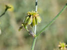
| Eriogonum jamesii
| 
Eriogonum jamesii beside the D&RGW track. | Photographed 25 July 2018.
Article records that use this photograph:
images/20180725_133156sm.jpg
| Eriogonum maculatum
| 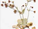
Coll. No. 446, Eriogonum maculatum, from the Mesquite Mountains. | Scanned 22-Jan-06.
Article records that use this photograph:
images/TAS004460.jpg
| Eriogonum microthecum
| 
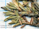
Coll. No. 97, Eriogonum microthecum | Scanned 22 October 2012. There are no flowers on this collection. Collection discarded.
Article records that use this photograph:
images/TAS000970Oview.jpg
| Eriogonum microthecum ambiguum
| 
Leaves of Collection No. 558, Eriogonum microthecum var. ambiguum |
Article records that use this photograph:
images/TAS005580lvs.jpg
| 
Inflorescence of Collection No. 558, Eriogonum microthecum var. ambiguum | The thing to see in this photo are yellow flowers without a stipe.
Article records that use this photograph:
images/TAS005580infl.jpg
| 
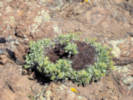
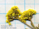
Overview of Collection No. 558, Eriogonum microthecum var. ambiguum | The thing to notice about this collection is a subshrub with upright woody branches.
Article records that use this photograph:
images/TAS005580oview.jpg
| 
Overview of Coll. No. 678, Eriogonum microthecum var. ambiguum | Scanned 27 Oct 2011. 27 Oct 2011: Characters observed while keying: Subshrub ± erect (not cushion-like or matted); Stems upright, not jointed; Leaves not in fascicles, 10-20 mm, slightly rolled under; Bracts scale-like (as opposed to leaf-like); Infloresence branches short, evenly branched; Involucres solitary, terminal; Perianth base not jointed with a pedicel, glabrous, yellow.
Article records that use this photograph:
images/TAS006780Oview.jpg
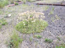
| 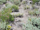
Habitat of Eriogonum microthecum var. ambiguum | Photograph taken 22 Jul 2010. This was the location of my collection #678.
Article records that use this photograph:
images/IMGP0570sm.jpg
| Eriogonum microthecum laxiflorum
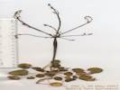
| 
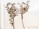
Coll. No. 798, Eriogonum microthecum var. laxiflorum | Scanned 30 Dec 2011. Coll. No, 798, 30 Dec 2011, characters observed while keying: Perennial erect shrub with woody branches; Leaves not fasciculate, slightly revolute; Infloresence of solitary involucres, branches equal in size; Perianth base not expanded into a small stipe and jointed with pedicel; Flowers white to pink.
Article records that use this photograph:
images/TAS007980Oview.jpg
| Eriogonum nidularium
| 
Coll. No. 320, Eriogonum nidularium | Scanned 17 October 2012.
Article records that use this photograph:
images/TAS00320Oview.jpg
| 
Coll. No. 320, Eriogonum nidularium | Scanned 17 October 2012. Scale bar is 10 mm.
Article records that use this photograph:
images/TAS00320Det.jpg
| Eriogonum nudum
| 
Coll. No. 700, Eriogonum nudum | Scanned 13 Nov 2011. Coll. No. 700, 13 Nov 2011, characters observed while keying; Perennial herbaceous, erect; Leaves basal, 22-32 mm, elliptic, subglabrous above (glabrous with a few cobwebby hairs); Infloresence in cymose heads, glabrous; Tepals glabrous; Perianth base entire (not jointed).
Article records that use this photograph:
images/TAS007000Oview.jpg
| Eriogonum nummulare
| 
Coll. No. 574, Eriogonum nummulare | Scanned May 6, 2010, grid is 10x10 to the inch. Determination tentative, material was immature and was therefore discarded.
Article records that use this photograph:
images/TAS005740Lvs.jpg
| 
Coll. No. 574, Eriogonum nummulare | Scanned May 6, 2010, grid is 10x10 to the inch. Determination tentative, material was immature and was therefore discarded.
Article records that use this photograph:
images/TAS005740Infl.jpg
| | ||||||||||||||||||||||||||||||||||||||||||||||||||||